I have long been aware of a story that Strathbungo was threatened by a motorway in the 1960s, and this was a crucial event in the formation of the Strathbungo Society, but I have never understood how this could be. The M77 perhaps? But that was always going to be further west. So what was the story?
There were occasional hints. A neighbour gave me an old article from Scottish Field dated 1977 in which Mike Stanger, then chair of the Society, described how properties were blighted by the planned South Link motorway, with no one able to get a mortgage, not even on 1-10 Moray Place.
A Society booklet of 1984 recounts the same story .
But what was the South Link? And why did it threaten the very existence of Strathbungo? With thanks to Stuart Baird, of the Glasgow Motorway Archive , we now know. Read on…
Grandiose Plans
Glasgow has a fascinating history of grand post war proposals for urban redesign, to deal with its problems of poverty, overcrowding, and lack of decent housing. However one can’t help reading them without breathing a sigh of relief they were only ever implemented in part.
First there was the City Corporation’s Bruce Report of 1945; flatten the city entirely and build an new urban utopia . If you find that hard to imagine, watch a clip from a recent BBC documentary, which illustrates it beautifully . Bruce was the first to suggest an inner city ring road, and this idea survived even though most of his plan was ultimately rejected.
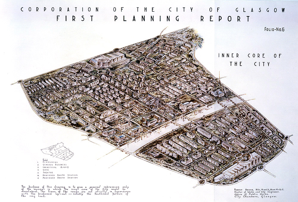
Bruce Report 1945
Then followed the Clyde Valley Regional Plan by Sir Patrick Abercrombie, a rival from the Scottish Office, which proposed moving people to New Towns such as East Kilbride and Cumbernauld.
In the 1950s the Comprehensive Development Areas (CDAs) arrived; zoning of areas of the city, and earmarking those for wholescale demolition of slum housing, with relocation of residents, either to New Towns, or new housing within Glasgow. The first such area to be approved was Hutchesontown-Gorbals in 1957 . Other areas destined to be wiped out included Townhead (partly zoned for university use, now Strathclyde University) and Anderston. The inner ring road took advantage of these CDAs to negotiate a route round the city.
The Highway Plan for Glasgow
Commissioned in 1960, the plan was another component of the attempts to deal with Glasgow’s post war problems. An outline of the proposed ring road was produced in 1962, and the final plan published in 1965. It proposed a total of 48 miles of motorway within the city boundary . The intention for the ring road was to remove traffic from the city centre, while where possible following a route through areas of poor housing already earmarked for demolition. It was also the first report to suggest pedestrianisation of central streets such as Sauchiehall & Argyle Streets. Traffic flows were studied on an IBM mainframe computer in the US, and the designs were created with the aid of American freeway designers – no one in the UK had any experience of urban road building on such a scale.

Inner Ring Road Proposal
The north and west flanks were constructed between 1968 and 1972, but the south and east flanks were cancelled in 1980. Some radial routes were built, such as the Great Western Road expressway, and the M77, while others, such as the Maryhill motorway, never made it off the drawing board. Occasional glimpses of what might have been are evident; the slip roads off the wrong side of the M8 for the Maryhill motorway still exist, but go nowhere. The ski ramps south of Kingston Bridge were for the south flank. Even the short curve of dual carriageway on Laurieston Road as you approach Gorbals Pool and the Albert Bridge is laid out that way because it’s the south east corner of the proposed ring road. One of the illustrations suggests how it might have looked, approaching that corner.
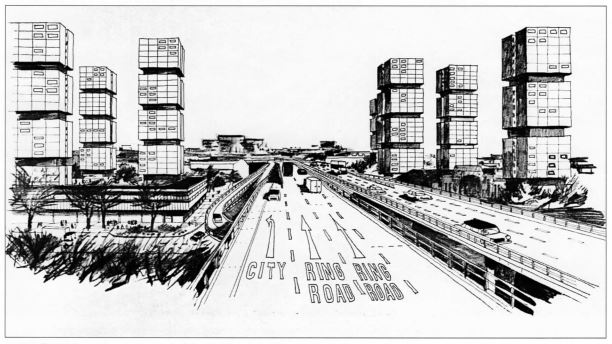
Inner Ring Road, south flank (unbuilt)
The plan also considered a much larger network of motorways and expressways around Glasgow, illustrated below. The CDAs are also visible on this map, outlined in black.

Urban motorways plan
Greater Glasgow Transportation Study
The Highway Plan ended at Glasgow’s boundaries, but neighbouring authorities became involved, and the Greater Glasgow Transportation Study of 1967 was even more ambitious . Its four volumes up to 1973 covered not only roads, but neighbourhood and commercial planning, and public transportation. It even contains a detailed plan for a new shopping arcade in Shawlands as an example of neighbourhood regeneration, surprisingly similar to what was actually built later. The plan appeared to be to allow access to car parking from Pollokshaws Road behind, while Kilmarnock Road was to become a high speed expressway. I wonder if this explains the curious elevated pavement at the arcade; to keep pedestrians away from the expressway below.

Shawlands Arcade Proposal
Strathbungo
So far, so good. Or bad, depending on your environmental viewpoint. But what was it to Strathbungo? For that you need to study the more detailed plans for the East/South Link Motorways, to run from the proposed M8/M80 south through the east of the city towards Hampden, then west to connect with the M77 and M8 in Dumbreck/Ibrox. Detailed route maps were in the study, and are reproduced here, again with thanks to Stuart Baird. Click any image to enlarge.

South Link, Eastern Section. Prospecthill Rooad, Hampden & Cathkin Park in centre
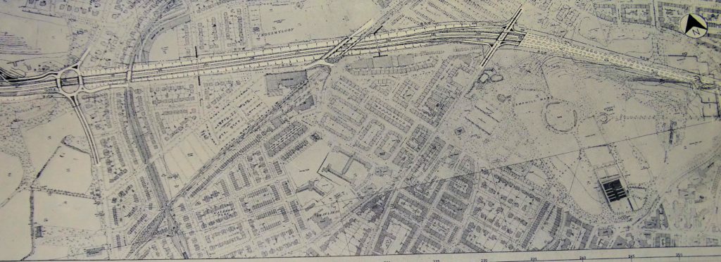
South Link, central section, Strathbungo & Queens Park – note how the motorway emerges from under the duck pond and the junction with Pollokshaws Road destroys the gardens and part of Marywood Square.

South Link, Western Section, Dumbreck
Close inspection of the central section map shows what effect this would have had on Strathbungo. The four lane motorway was to tunnel under Queens Park, before emerging from under the duckpond. It would pass under Pollokshaws Road, and run along Titwood Road in a deep cutting. There were off ramps to connect with the proposed Pollokshaws Road expressway, and the Squares would likely have been closed off at their junctions with Pollokshaws Road. More importantly, Carswell Gardens, Thorncliffe Gardens, Vennard Gardens and the bottom of Marywood Square would have been obliterated completely, along with one or two of the Pollokshaws Road tenements. Oops.
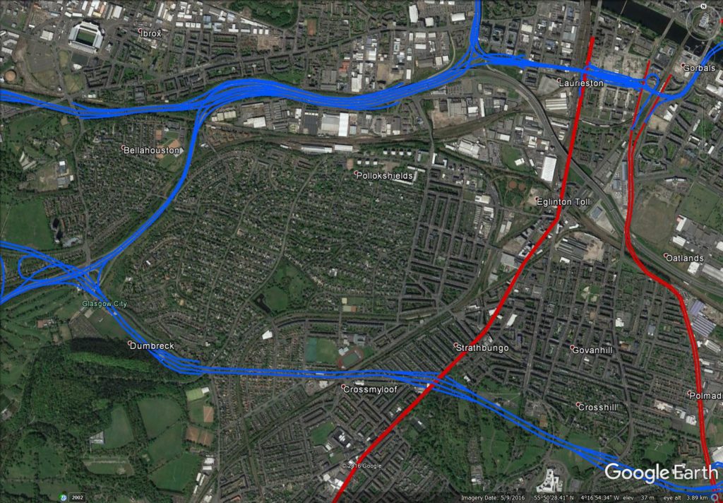
Southside motorway proposals, overlaid on Google images.
The full Google Earth overlay is available to download on the cbrd website, if you want to explore further.
The Strathbungo Society and the Conservation Area
The Strathbungo Society was formed in 1971 as part of a campaign to save Strathbungo from further decline and to seek Conservation Area status, partly in response to the motorway threat, and under the auspices of the Scottish Civic Trust . Conservation Areas were introduced by Act of Parliament in 1967, and Strathbungo was designated on 10th July 1973 by Glasgow Corporation. The conservation area extended from Nithsdale Road to the Gardens, partly to protect the gardens from the motorway proposals. The motorway threat appears to have finally lifted in January 1976 , and on 24th August 1978 the area was redefined by Glasgow District Council, removing the gardens, but extending to include Salisbury Quadrant and all of Nithsdale Road . This reduced the burden of a conservation area on residents in the gardens, but it is unclear if they gave this their support or not.
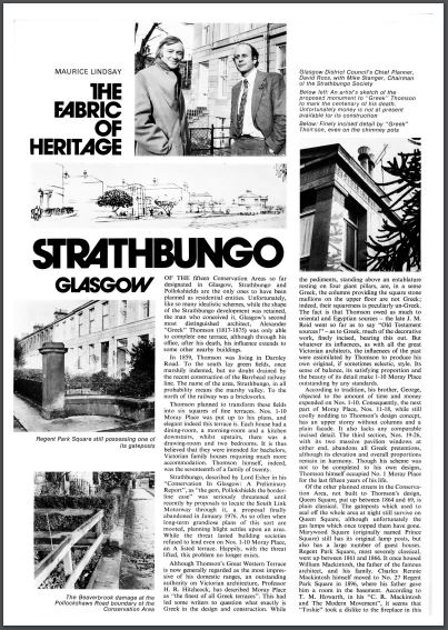
Scottish Field Article, describing the origins of the Strathbungo Society, January 1977 – click for pdf.
The current conservation area boundary is shown below .
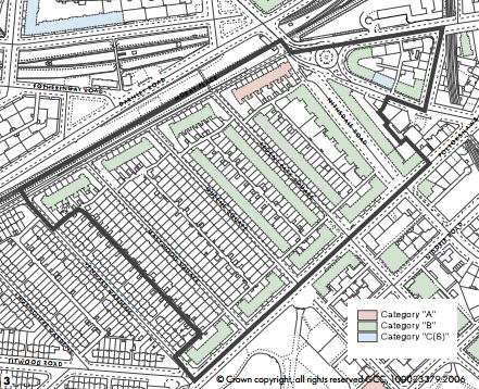
Conservation Area Boundary and Building listings, taken from 2006 Conservation Area Appraisal
Strathbungo had thus been blighted for almost 10 years. Following cancellation however, the area has recovered, and now goes from strength to strength. Thanks to the efforts of the then members of the Strathbungo Society, and others, what might have been is now largely forgotten.
References
{3557955:6338ECTX};{3557955:56QVT3WH};{3557955:NQHV5GBC};{3557955:BEPT5XAZ};{3557955:4Q7HWG3C};{3557955:D8AF2NKS};{3557955:NQHV5GBC};{3557955:FRHGE4WW};{3557955:84MKW8EW};{3557955:6338ECTX};{3557955:56QVT3WH};{3557955:5B3M28UX}
vancouver
asc
0
640
%7B%22status%22%3A%22success%22%2C%22updateneeded%22%3Afalse%2C%22instance%22%3A%22zotpress-11027c08a9223396dcc7389970f313f9%22%2C%22meta%22%3A%7B%22request_last%22%3A0%2C%22request_next%22%3A0%2C%22used_cache%22%3Atrue%7D%2C%22data%22%3A%5B%7B%22key%22%3A%22BEPT5XAZ%22%2C%22library%22%3A%7B%22id%22%3A3557955%7D%2C%22meta%22%3A%7B%22parsedDate%22%3A%222017-01-11%22%2C%22numChildren%22%3A1%7D%2C%22bib%22%3A%22%3Cdiv%20class%3D%5C%22csl-bib-body%5C%22%20style%3D%5C%22line-height%3A%201.35%3B%20%5C%22%3E%5Cn%20%20%3Cdiv%20class%3D%5C%22csl-entry%5C%22%20style%3D%5C%22clear%3A%20left%3B%20%5C%22%3E%5Cn%20%20%20%20%3Cdiv%20class%3D%5C%22csl-left-margin%5C%22%20style%3D%5C%22float%3A%20left%3B%20padding-right%3A%200.5em%3B%20text-align%3A%20right%3B%20width%3A%201em%3B%5C%22%3E1.%3C%5C%2Fdiv%3E%3Cdiv%20class%3D%5C%22csl-right-inline%5C%22%20style%3D%5C%22margin%3A%200%20.4em%200%201.5em%3B%5C%22%3EBruce%20Report.%20In%3A%20Wikipedia%20%5BInternet%5D.%202017%20%5Bcited%202017%20Feb%202%5D.%20Available%20from%3A%20%3Ca%20href%3D%27https%3A%5C%2F%5C%2Fen.wikipedia.org%5C%2Fw%5C%2Findex.php%3Ftitle%3DBruce_Report%27%3Ehttps%3A%5C%2F%5C%2Fen.wikipedia.org%5C%2Fw%5C%2Findex.php%3Ftitle%3DBruce_Report%3C%5C%2Fa%3E%3C%5C%2Fdiv%3E%5Cn%20%20%3C%5C%2Fdiv%3E%5Cn%3C%5C%2Fdiv%3E%22%2C%22data%22%3A%7B%22itemType%22%3A%22encyclopediaArticle%22%2C%22title%22%3A%22Bruce%20Report%22%2C%22creators%22%3A%5B%5D%2C%22abstractNote%22%3A%22The%20Bruce%20Report%20%28or%20the%20Bruce%20Plan%29%20is%20the%20name%20commonly%20given%20to%20the%20First%20Planning%20Report%20to%20the%20Highways%20and%20Planning%20Committee%20of%20the%20Corporation%20of%20the%20City%20of%20Glasgow%20published%20in%20March%201945.%20It%20influenced%20an%20intensive%20programme%20of%20regeneration%20and%20rebuilding%20efforts%20which%20took%20place%20in%20the%20city%20and%20surroundings%20from%20the%20mid-1950s%20and%20lasted%20until%20the%20late%201970s.%20The%20author%20was%20Robert%20Bruce%2C%20Glasgow%20Corporation%20Engineer%20at%20the%20time.%5CnA%20few%20years%20later%20in%201949%20the%20Scottish%20Office%20in%20Edinburgh%20issued%20its%20rival%20Clyde%20Valley%20Regional%20Plan%201946%20%28%27CVP%27%29.%20This%20was%20authored%20by%20a%20team%20led%20by%20Sir%20Patrick%20Abercrombie%20and%20Robert%20H%20Matthew%20and%20disagreed%20with%20the%20Bruce%20Report%20in%20a%20number%20of%20important%20areas.%20In%20particular%20the%20CVP%20recommended%20an%20overspill%20policy%20for%20Glasgow%20and%20the%20rehousing%20of%20much%20of%20the%20population%20in%20new%20towns%20outside%20the%20city.%20The%20Bruce%20Report%20preferred%20rebuilding%20and%20rehousing%20within%20the%20city%20boundary.%20The%20friction%20and%20debate%20between%20the%20supporters%20and%20spheres%20of%20influence%20for%20these%20two%20reports%20led%20to%20a%20series%20of%20initiatives%20designed%20to%20transform%20the%20city%20over%20the%20following%20fifty%20years.%5CnSome%20of%20the%20Bruce%20Report%20initiatives%20were%20put%20into%20practice%3B%20others%20were%20not.%20The%20report%20and%20its%20implementation%20significantly%20shaped%20modern%20day%20Glasgow.%20A%20good%20example%20of%20the%20scope%20of%20its%20impact%20is%20the%20M8%20motorway%20which%20was%20built%20following%20proposals%20in%20the%20report.%20Also%20the%20mid-20th%20century%20policy%20or%20resettling%20much%20of%20the%20city%27s%20population%20to%20peripheral%20housing%20schemes%20arose%20from%20recommendations%20in%20the%20Bruce%20Report%2C%20reflecting%20Glasgow%20Corporation%27s%20resistance%20to%20overspill%20and%20new%20towns%20until%20it%20co-operated%20in%20the%20designation%20of%20Cumbernauld%20new%20town%20in%201956.%20The%20civic%2C%20economic%2C%20political%2C%20architectural%2C%20geographic%20and%20demographic%20landscape%20of%20modern%20Glasgow%20would%20have%20been%20radically%20different%20without%20the%20influence%20of%20these%20two%20reports.%20Had%20the%20Bruce%20Report%20itself%20been%20implemented%20unaltered%20in%20its%20entirety%2C%20the%20city%20today%20would%20probably%20have%20been%20unrecognisable.%22%2C%22encyclopediaTitle%22%3A%22Wikipedia%22%2C%22date%22%3A%222017-01-11T01%3A06%3A41Z%22%2C%22ISBN%22%3A%22%22%2C%22url%22%3A%22https%3A%5C%2F%5C%2Fen.wikipedia.org%5C%2Fw%5C%2Findex.php%3Ftitle%3DBruce_Report%22%2C%22language%22%3A%22en%22%2C%22collections%22%3A%5B%22CAR6MXPM%22%5D%2C%22dateModified%22%3A%222017-02-02T15%3A29%3A23Z%22%7D%7D%2C%7B%22key%22%3A%225B3M28UX%22%2C%22library%22%3A%7B%22id%22%3A3557955%7D%2C%22meta%22%3A%7B%22parsedDate%22%3A%222015-11-03%22%2C%22numChildren%22%3A1%7D%2C%22bib%22%3A%22%3Cdiv%20class%3D%5C%22csl-bib-body%5C%22%20style%3D%5C%22line-height%3A%201.35%3B%20%5C%22%3E%5Cn%20%20%3Cdiv%20class%3D%5C%22csl-entry%5C%22%20style%3D%5C%22clear%3A%20left%3B%20%5C%22%3E%5Cn%20%20%20%20%3Cdiv%20class%3D%5C%22csl-left-margin%5C%22%20style%3D%5C%22float%3A%20left%3B%20padding-right%3A%200.5em%3B%20text-align%3A%20right%3B%20width%3A%201em%3B%5C%22%3E1.%3C%5C%2Fdiv%3E%3Cdiv%20class%3D%5C%22csl-right-inline%5C%22%20style%3D%5C%22margin%3A%200%20.4em%200%201.5em%3B%5C%22%3EStrathbungo%20conservation%20area%20appraisal%20%5BInternet%5D.%20Glasgow%20City%20Council%3B%202015%20%5Bcited%202017%20Jan%206%5D.%20Available%20from%3A%20%3Ca%20href%3D%27http%3A%5C%2F%5C%2Fbygone.bungoblog.com%5C%2Fwp%5C%2Fwp-content%5C%2Fuploads%5C%2FStrathbungo-Conservation-Area-Appraisal.pdf%27%3Ehttp%3A%5C%2F%5C%2Fbygone.bungoblog.com%5C%2Fwp%5C%2Fwp-content%5C%2Fuploads%5C%2FStrathbungo-Conservation-Area-Appraisal.pdf%3C%5C%2Fa%3E%3C%5C%2Fdiv%3E%5Cn%20%20%3C%5C%2Fdiv%3E%5Cn%3C%5C%2Fdiv%3E%22%2C%22data%22%3A%7B%22itemType%22%3A%22document%22%2C%22title%22%3A%22Strathbungo%20conservation%20area%20appraisal%22%2C%22creators%22%3A%5B%5D%2C%22abstractNote%22%3A%22%22%2C%22date%22%3A%222015-11-03%22%2C%22language%22%3A%22en%22%2C%22url%22%3A%22http%3A%5C%2F%5C%2Fbygone.bungoblog.com%5C%2Fwp%5C%2Fwp-content%5C%2Fuploads%5C%2FStrathbungo-Conservation-Area-Appraisal.pdf%22%2C%22collections%22%3A%5B%22CAR6MXPM%22%5D%2C%22dateModified%22%3A%222017-02-02T15%3A06%3A40Z%22%7D%7D%2C%7B%22key%22%3A%2284MKW8EW%22%2C%22library%22%3A%7B%22id%22%3A3557955%7D%2C%22meta%22%3A%7B%22numChildren%22%3A1%7D%2C%22bib%22%3A%22%3Cdiv%20class%3D%5C%22csl-bib-body%5C%22%20style%3D%5C%22line-height%3A%201.35%3B%20%5C%22%3E%5Cn%20%20%3Cdiv%20class%3D%5C%22csl-entry%5C%22%20style%3D%5C%22clear%3A%20left%3B%20%5C%22%3E%5Cn%20%20%20%20%3Cdiv%20class%3D%5C%22csl-left-margin%5C%22%20style%3D%5C%22float%3A%20left%3B%20padding-right%3A%200.5em%3B%20text-align%3A%20right%3B%20width%3A%201em%3B%5C%22%3E1.%3C%5C%2Fdiv%3E%3Cdiv%20class%3D%5C%22csl-right-inline%5C%22%20style%3D%5C%22margin%3A%200%20.4em%200%201.5em%3B%5C%22%3EHistory%20of%20the%20Trust%20-%20Scottish%20Civic%20Trust%20%5BInternet%5D.%20%5Bcited%202017%20Feb%202%5D.%20Available%20from%3A%20%3Ca%20href%3D%27http%3A%5C%2F%5C%2Fwww.scottishcivictrust.org.uk%5C%2Fabout%5C%2Fhistory-of-the-trust%5C%2F%27%3Ehttp%3A%5C%2F%5C%2Fwww.scottishcivictrust.org.uk%5C%2Fabout%5C%2Fhistory-of-the-trust%5C%2F%3C%5C%2Fa%3E%3C%5C%2Fdiv%3E%5Cn%20%20%3C%5C%2Fdiv%3E%5Cn%3C%5C%2Fdiv%3E%22%2C%22data%22%3A%7B%22itemType%22%3A%22webpage%22%2C%22title%22%3A%22History%20of%20the%20Trust%20-%20Scottish%20Civic%20Trust%22%2C%22creators%22%3A%5B%5D%2C%22abstractNote%22%3A%22%22%2C%22date%22%3A%22%22%2C%22url%22%3A%22http%3A%5C%2F%5C%2Fwww.scottishcivictrust.org.uk%5C%2Fabout%5C%2Fhistory-of-the-trust%5C%2F%22%2C%22language%22%3A%22%22%2C%22collections%22%3A%5B%22CAR6MXPM%22%5D%2C%22dateModified%22%3A%222017-02-02T14%3A57%3A49Z%22%7D%7D%2C%7B%22key%22%3A%22D8AF2NKS%22%2C%22library%22%3A%7B%22id%22%3A3557955%7D%2C%22meta%22%3A%7B%22numChildren%22%3A1%7D%2C%22bib%22%3A%22%3Cdiv%20class%3D%5C%22csl-bib-body%5C%22%20style%3D%5C%22line-height%3A%201.35%3B%20%5C%22%3E%5Cn%20%20%3Cdiv%20class%3D%5C%22csl-entry%5C%22%20style%3D%5C%22clear%3A%20left%3B%20%5C%22%3E%5Cn%20%20%20%20%3Cdiv%20class%3D%5C%22csl-left-margin%5C%22%20style%3D%5C%22float%3A%20left%3B%20padding-right%3A%200.5em%3B%20text-align%3A%20right%3B%20width%3A%201em%3B%5C%22%3E1.%3C%5C%2Fdiv%3E%3Cdiv%20class%3D%5C%22csl-right-inline%5C%22%20style%3D%5C%22margin%3A%200%20.4em%200%201.5em%3B%5C%22%3ETheGlasgowStory%3A%201950s%20to%20The%20Present%20Day%3A%20Neighbourhoods%20%5BInternet%5D.%20%5Bcited%202017%20Feb%202%5D.%20Available%20from%3A%20%3Ca%20href%3D%27http%3A%5C%2F%5C%2Fwww.theglasgowstory.com%5C%2Fstory%5C%2F%3Fid%3DTGSFG%27%3Ehttp%3A%5C%2F%5C%2Fwww.theglasgowstory.com%5C%2Fstory%5C%2F%3Fid%3DTGSFG%3C%5C%2Fa%3E%3C%5C%2Fdiv%3E%5Cn%20%20%3C%5C%2Fdiv%3E%5Cn%3C%5C%2Fdiv%3E%22%2C%22data%22%3A%7B%22itemType%22%3A%22webpage%22%2C%22title%22%3A%22TheGlasgowStory%3A%201950s%20to%20The%20Present%20Day%3A%20Neighbourhoods%22%2C%22creators%22%3A%5B%5D%2C%22abstractNote%22%3A%22%22%2C%22date%22%3A%22%22%2C%22url%22%3A%22http%3A%5C%2F%5C%2Fwww.theglasgowstory.com%5C%2Fstory%5C%2F%3Fid%3DTGSFG%22%2C%22language%22%3A%22%22%2C%22collections%22%3A%5B%22CAR6MXPM%22%5D%2C%22dateModified%22%3A%222017-02-02T10%3A32%3A49Z%22%7D%7D%2C%7B%22key%22%3A%224Q7HWG3C%22%2C%22library%22%3A%7B%22id%22%3A3557955%7D%2C%22meta%22%3A%7B%22numChildren%22%3A1%7D%2C%22bib%22%3A%22%3Cdiv%20class%3D%5C%22csl-bib-body%5C%22%20style%3D%5C%22line-height%3A%201.35%3B%20%5C%22%3E%5Cn%20%20%3Cdiv%20class%3D%5C%22csl-entry%5C%22%20style%3D%5C%22clear%3A%20left%3B%20%5C%22%3E%5Cn%20%20%20%20%3Cdiv%20class%3D%5C%22csl-left-margin%5C%22%20style%3D%5C%22float%3A%20left%3B%20padding-right%3A%200.5em%3B%20text-align%3A%20right%3B%20width%3A%201em%3B%5C%22%3E1.%3C%5C%2Fdiv%3E%3Cdiv%20class%3D%5C%22csl-right-inline%5C%22%20style%3D%5C%22margin%3A%200%20.4em%200%201.5em%3B%5C%22%3EBBC%20%5BInternet%5D.%20%5Bcited%202017%20Feb%202%5D.%20The%20Bruce%20Plan%20for%20Glasgow%2C%20A%20Revolution%20in%20the%20City%2C%20Dreaming%20the%20Impossible%3A%20Unbuilt%20Britain%20-%20BBC%20Four.%20Available%20from%3A%20%3Ca%20href%3D%27http%3A%5C%2F%5C%2Fwww.bbc.co.uk%5C%2Fprogrammes%5C%2Fp01fjyjv%27%3Ehttp%3A%5C%2F%5C%2Fwww.bbc.co.uk%5C%2Fprogrammes%5C%2Fp01fjyjv%3C%5C%2Fa%3E%3C%5C%2Fdiv%3E%5Cn%20%20%3C%5C%2Fdiv%3E%5Cn%3C%5C%2Fdiv%3E%22%2C%22data%22%3A%7B%22itemType%22%3A%22webpage%22%2C%22title%22%3A%22The%20Bruce%20Plan%20for%20Glasgow%2C%20A%20Revolution%20in%20the%20City%2C%20Dreaming%20the%20Impossible%3A%20Unbuilt%20Britain%20-%20BBC%20Four%22%2C%22creators%22%3A%5B%5D%2C%22abstractNote%22%3A%22Dr%20Olivia%20Horsfall%20Turner%20on%20the%20plans%20to%20demolish%20Glasgow%27s%20city%20centre.%22%2C%22date%22%3A%22%22%2C%22url%22%3A%22http%3A%5C%2F%5C%2Fwww.bbc.co.uk%5C%2Fprogrammes%5C%2Fp01fjyjv%22%2C%22language%22%3A%22%22%2C%22collections%22%3A%5B%22CAR6MXPM%22%5D%2C%22dateModified%22%3A%222017-02-02T10%3A04%3A34Z%22%7D%7D%2C%7B%22key%22%3A%22FRHGE4WW%22%2C%22library%22%3A%7B%22id%22%3A3557955%7D%2C%22meta%22%3A%7B%22numChildren%22%3A1%7D%2C%22bib%22%3A%22%3Cdiv%20class%3D%5C%22csl-bib-body%5C%22%20style%3D%5C%22line-height%3A%201.35%3B%20%5C%22%3E%5Cn%20%20%3Cdiv%20class%3D%5C%22csl-entry%5C%22%20style%3D%5C%22clear%3A%20left%3B%20%5C%22%3E%5Cn%20%20%20%20%3Cdiv%20class%3D%5C%22csl-left-margin%5C%22%20style%3D%5C%22float%3A%20left%3B%20padding-right%3A%200.5em%3B%20text-align%3A%20right%3B%20width%3A%201em%3B%5C%22%3E1.%3C%5C%2Fdiv%3E%3Cdiv%20class%3D%5C%22csl-right-inline%5C%22%20style%3D%5C%22margin%3A%200%20.4em%200%201.5em%3B%5C%22%3ECBRD%26%23x202F%3B%26%23xBB%3B%20Articles%26%23x202F%3B%26%23xBB%3B%20Glasgow%20%5BInternet%5D.%20%5Bcited%202017%20Feb%202%5D.%20Available%20from%3A%20%3Ca%20href%3D%27http%3A%5C%2F%5C%2Fwww.cbrd.co.uk%5C%2Farticles%5C%2Fglasgow%5C%2F%27%3Ehttp%3A%5C%2F%5C%2Fwww.cbrd.co.uk%5C%2Farticles%5C%2Fglasgow%5C%2F%3C%5C%2Fa%3E%3C%5C%2Fdiv%3E%5Cn%20%20%3C%5C%2Fdiv%3E%5Cn%3C%5C%2Fdiv%3E%22%2C%22data%22%3A%7B%22itemType%22%3A%22webpage%22%2C%22title%22%3A%22CBRD%20%5Cu00bb%20Articles%20%5Cu00bb%20Glasgow%22%2C%22creators%22%3A%5B%5D%2C%22abstractNote%22%3A%22%22%2C%22date%22%3A%22%22%2C%22url%22%3A%22http%3A%5C%2F%5C%2Fwww.cbrd.co.uk%5C%2Farticles%5C%2Fglasgow%5C%2F%22%2C%22language%22%3A%22%22%2C%22collections%22%3A%5B%22CAR6MXPM%22%5D%2C%22dateModified%22%3A%222017-02-02T09%3A20%3A05Z%22%7D%7D%2C%7B%22key%22%3A%22NQHV5GBC%22%2C%22library%22%3A%7B%22id%22%3A3557955%7D%2C%22meta%22%3A%7B%22numChildren%22%3A1%7D%2C%22bib%22%3A%22%3Cdiv%20class%3D%5C%22csl-bib-body%5C%22%20style%3D%5C%22line-height%3A%201.35%3B%20%5C%22%3E%5Cn%20%20%3Cdiv%20class%3D%5C%22csl-entry%5C%22%20style%3D%5C%22clear%3A%20left%3B%20%5C%22%3E%5Cn%20%20%20%20%3Cdiv%20class%3D%5C%22csl-left-margin%5C%22%20style%3D%5C%22float%3A%20left%3B%20padding-right%3A%200.5em%3B%20text-align%3A%20right%3B%20width%3A%201em%3B%5C%22%3E1.%3C%5C%2Fdiv%3E%3Cdiv%20class%3D%5C%22csl-right-inline%5C%22%20style%3D%5C%22margin%3A%200%20.4em%200%201.5em%3B%5C%22%3EGlasgow%26%23x2019%3Bs%20Motorways%20%5BInternet%5D.%20%5Bcited%202017%20Feb%202%5D.%20Available%20from%3A%20%3Ca%20href%3D%27http%3A%5C%2F%5C%2Fwww.glasgows-motorways.co.uk%27%3Ehttp%3A%5C%2F%5C%2Fwww.glasgows-motorways.co.uk%3C%5C%2Fa%3E%3C%5C%2Fdiv%3E%5Cn%20%20%3C%5C%2Fdiv%3E%5Cn%3C%5C%2Fdiv%3E%22%2C%22data%22%3A%7B%22itemType%22%3A%22webpage%22%2C%22title%22%3A%22Glasgow%27s%20Motorways%22%2C%22creators%22%3A%5B%5D%2C%22abstractNote%22%3A%22The%20Glasgow%20Motorway%20Archive%20is%20an%20independent%20educational%20website%20detailing%20the%20history%20%26%20construction%20of%20the%20motorways%20and%20major%20trunk%20roads%20of%20the%20Greater%20Glasgow%20area.%22%2C%22date%22%3A%22%22%2C%22url%22%3A%22http%3A%5C%2F%5C%2Fwww.glasgows-motorways.co.uk%22%2C%22language%22%3A%22%22%2C%22collections%22%3A%5B%22CAR6MXPM%22%5D%2C%22dateModified%22%3A%222017-02-02T09%3A19%3A57Z%22%7D%7D%2C%7B%22key%22%3A%226338ECTX%22%2C%22library%22%3A%7B%22id%22%3A3557955%7D%2C%22meta%22%3A%7B%22creatorSummary%22%3A%22Lindsay%22%2C%22parsedDate%22%3A%221977-01%22%2C%22numChildren%22%3A0%7D%2C%22bib%22%3A%22%3Cdiv%20class%3D%5C%22csl-bib-body%5C%22%20style%3D%5C%22line-height%3A%201.35%3B%20%5C%22%3E%5Cn%20%20%3Cdiv%20class%3D%5C%22csl-entry%5C%22%20style%3D%5C%22clear%3A%20left%3B%20%5C%22%3E%5Cn%20%20%20%20%3Cdiv%20class%3D%5C%22csl-left-margin%5C%22%20style%3D%5C%22float%3A%20left%3B%20padding-right%3A%200.5em%3B%20text-align%3A%20right%3B%20width%3A%201em%3B%5C%22%3E1.%3C%5C%2Fdiv%3E%3Cdiv%20class%3D%5C%22csl-right-inline%5C%22%20style%3D%5C%22margin%3A%200%20.4em%200%201.5em%3B%5C%22%3ELindsay%20M.%20The%20Fabric%20of%20Heritage%3A%20Strathbungo%20Glasgow.%20Scottish%20Field%20%5BInternet%5D.%201977%20Jan%3B26%26%23x2013%3B7.%20Available%20from%3A%20%3Ca%20href%3D%27http%3A%5C%2F%5C%2Fbygone.bungoblog.com%5C%2Fwp%5C%2Fwp-content%5C%2Fuploads%5C%2FScottishField.pdf%27%3Ehttp%3A%5C%2F%5C%2Fbygone.bungoblog.com%5C%2Fwp%5C%2Fwp-content%5C%2Fuploads%5C%2FScottishField.pdf%3C%5C%2Fa%3E%3C%5C%2Fdiv%3E%5Cn%20%20%3C%5C%2Fdiv%3E%5Cn%3C%5C%2Fdiv%3E%22%2C%22data%22%3A%7B%22itemType%22%3A%22magazineArticle%22%2C%22title%22%3A%22The%20Fabric%20of%20Heritage%3A%20Strathbungo%20Glasgow%22%2C%22creators%22%3A%5B%7B%22creatorType%22%3A%22author%22%2C%22firstName%22%3A%22Maurice%22%2C%22lastName%22%3A%22Lindsay%22%7D%5D%2C%22abstractNote%22%3A%22%22%2C%22date%22%3A%22January%201977%22%2C%22language%22%3A%22%22%2C%22ISSN%22%3A%22%22%2C%22url%22%3A%22http%3A%5C%2F%5C%2Fbygone.bungoblog.com%5C%2Fwp%5C%2Fwp-content%5C%2Fuploads%5C%2FScottishField.pdf%22%2C%22collections%22%3A%5B%22CAR6MXPM%22%5D%2C%22dateModified%22%3A%222017-02-01T00%3A51%3A21Z%22%7D%7D%2C%7B%22key%22%3A%2256QVT3WH%22%2C%22library%22%3A%7B%22id%22%3A3557955%7D%2C%22meta%22%3A%7B%22parsedDate%22%3A%221982%22%2C%22numChildren%22%3A0%7D%2C%22bib%22%3A%22%3Cdiv%20class%3D%5C%22csl-bib-body%5C%22%20style%3D%5C%22line-height%3A%201.35%3B%20%5C%22%3E%5Cn%20%20%3Cdiv%20class%3D%5C%22csl-entry%5C%22%20style%3D%5C%22clear%3A%20left%3B%20%5C%22%3E%5Cn%20%20%20%20%3Cdiv%20class%3D%5C%22csl-left-margin%5C%22%20style%3D%5C%22float%3A%20left%3B%20padding-right%3A%200.5em%3B%20text-align%3A%20right%3B%20width%3A%201em%3B%5C%22%3E1.%3C%5C%2Fdiv%3E%3Cdiv%20class%3D%5C%22csl-right-inline%5C%22%20style%3D%5C%22margin%3A%200%20.4em%200%201.5em%3B%5C%22%3EStrathbungo%3A%20A%20place%20to%20live%20in%2C%20a%20place%20to%20be%20proud%20of%20%5BInternet%5D.%20The%20Strathbungo%20Society%3B%201982.%20Available%20from%3A%20%3Ca%20href%3D%27http%3A%5C%2F%5C%2Fbygone.bungoblog.com%5C%2Fwp%5C%2Fwp-content%5C%2Fuploads%5C%2FStrathbungo-Society-c1984.pdf%27%3Ehttp%3A%5C%2F%5C%2Fbygone.bungoblog.com%5C%2Fwp%5C%2Fwp-content%5C%2Fuploads%5C%2FStrathbungo-Society-c1984.pdf%3C%5C%2Fa%3E%3C%5C%2Fdiv%3E%5Cn%20%20%3C%5C%2Fdiv%3E%5Cn%3C%5C%2Fdiv%3E%22%2C%22data%22%3A%7B%22itemType%22%3A%22document%22%2C%22title%22%3A%22Strathbungo%3A%20A%20place%20to%20live%20in%2C%20a%20place%20to%20be%20proud%20of%22%2C%22creators%22%3A%5B%5D%2C%22abstractNote%22%3A%22%22%2C%22date%22%3A%221982%22%2C%22language%22%3A%22%22%2C%22url%22%3A%22http%3A%5C%2F%5C%2Fbygone.bungoblog.com%5C%2Fwp%5C%2Fwp-content%5C%2Fuploads%5C%2FStrathbungo-Society-c1984.pdf%22%2C%22collections%22%3A%5B%22CAR6MXPM%22%5D%2C%22dateModified%22%3A%222017-02-01T00%3A42%3A05Z%22%7D%7D%5D%7D
Like this:
Like Loading...


Leave a Reply