Category: Maps (page 1 of 3)

Southern Motors

Southern Motors operated out of a showroom and garage on the corner of Pollokshaws Road and Titwood Road, on land owned by the Wright family. Their plans for this land appear to have changed more than once.

The Cottages

Where the BP Garage sits now, there were once two substantial houses that dated from the 1850s or earlier. These were Springhill and Greenhill Cottages, at 898 and 910 Pollokshaws Road respectively. Springhill Cottage took its name from the nearby Springhill House – as did the red sandstone tenements of Springhill Gardens (built 1904-6, architect John Nisbet) which replaced the house.

Excerpt of map showing the two cottages on Pollokshaws Road

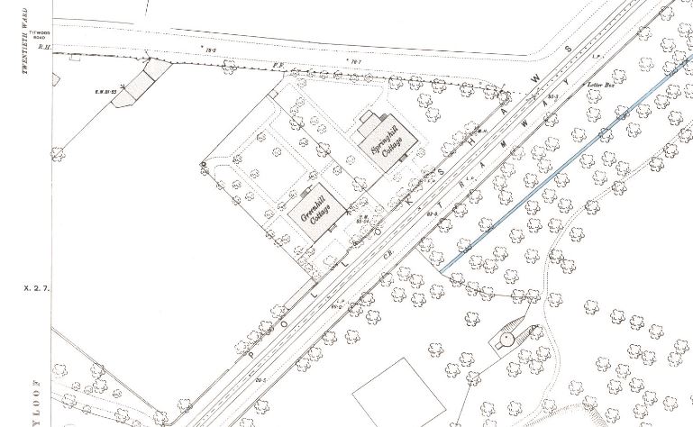
OS Map 1893. Source: NLS Maps

Continue reading

Hutchesontown Gardens

This is a story of Glasgow allotments, prompted by Andrew Greg’s discovery of this previously unseen old photograph of Strathbungo, on, of all things, the cover of an obscure Jazz CD.

In the first half of the nineteenth century, the idea of garden plots for city residents developed. The idea was to grow flowers and vegetables for recreation, and no traders or market gardeners were permitted.

Continue reading

Strathbungo’s fountain

Recently Douglas Robertson posted a query on the Bungoblog – did anyone else remember the Victorian drinking fountain on the Nithsdale Road roundabout, opposite Salisbury Quadrant?

“I’m sure it was Victorian, as made of metal and was substantially built. I don’t know the dimensions but would estimate (from memory) that it was approx. 10-12 ft high on a circular base of slightly larger dimensions.

It was situated on a roundabout opposite the old red telephone box nr. Sammy Dows and The New Anand Restaurant. I am sure it was still there about 20 years ago when I lived in Pollokshields. Did anyone see it being dismantled? Where did it finally end up? I have searched and searched (google uk) and cant find anything relating to it. I’m sure there must be someone, perhaps a Glasgow Council dept., who could throw some light on this. Again, a photo of it from someone would be an ideal start.”

A couple of residents replied, recalling the time the council came and took it away, or destroyed it when the new roundabout was constructed, probably in the mid 1970s.

Then the Strathbungo Society’s chair flagged it up to @OssianLore on Twitter , and the following is a summary of what he discovered.

Continue reading

« Older posts

© 2024 Bygone Bungo

Theme by Anders NorénUp ↑