This is a story of Glasgow allotments, prompted by Andrew Greg’s discovery of this previously unseen old photograph of Strathbungo, on, of all things, the cover of an obscure Jazz CD.
In the first half of the nineteenth century, the idea of garden plots for city residents developed. The idea was to grow flowers and vegetables for recreation, and no traders or market gardeners were permitted.
Gorbals
Hutchesontown Gardens was originally an area of land given over to garden plots in the Gorbals, between Cumberland Street and Caledonia Road around 1840 . Blackfriars Primary School now occupies the site.

Hutchesontown Gardens, Gorbals, OS Map 1865, gardens seen centre right
It moved in 1866 to a field between Victoria Road, Butterbiggins Road and Cathcart Road (in the vicinity of present day Govanhill Park and the former Samaritans Hospital). It covered 7.5 acres, with 157 plots. The following excerpt from the Glasgow Herald of 10 August 1866 describes the new location:
Hutchesontown Gardens – Our readers will observe that these extensive new gardens are to be opened to the public tomorrow for a grand promenade. From their present high state of cultivation, their fine situation and proximity to the town, as also the ample accommodation for promenading, we have little doubt a large number of our citizens will avail themselves of an opportunity only afforded once a year to witness the successful efforts of these highly intelligent and enterprising amateur horticulturalists. The splendid band of thee 21st Regiment has been kindly granted for the occasion by Colonel Stuart, C.B. and officers, which will add much to the day’s enjoyment.
From the same edition

Hutchesontown Gardens Advert, Glasgow Herald 1866

1870 PO Directory Map, New Hutchesontown Gardens mid right
Strathbungo
In 1876 it moved again, to a plot of land in the south east corner of Strathbungo village, south of Allison Street, and formerly known as the Spittal Croft . There were 194 plots over 8.75 acres.
In 1886 the first part of the Cathcart District Railway line opened, with the new Queens Park Station cutting through the southern end of the gardens, and reducing the size by a couple of acres. This photograph of Strathbungo taken in 1895 shows the gardens behind the station, with the centre of Strathbungo, including the last of the old whitewashed buildings, in the background .
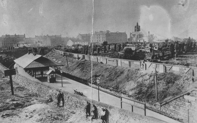
Queens Park Station c 1895, Virtual Mitchell, Hutchesontown Gardens behind
The gardens remained there until the 1890s, when they were displaced once again by encroaching development. In 1891, when Strathbungo became incorporated into the expanding city of Glasgow, the Corporation chose this as a site for new fire, police and lighting departments, and purchased the land.
In addition to the police and fire stations, Strathbungo School (now St Bride’s) was also built on the site, c 1894. The open space on Cragie Street was apparently left that way due to unsafe mine workings beneath.
The OS Map of 1896 shows the new streets being laid out before building began.

Hutchesontown Gardens OS Map 1896

Hutchesontown Gardens tenement under construction in 1896 (Photo Credit: Past Glasgow)
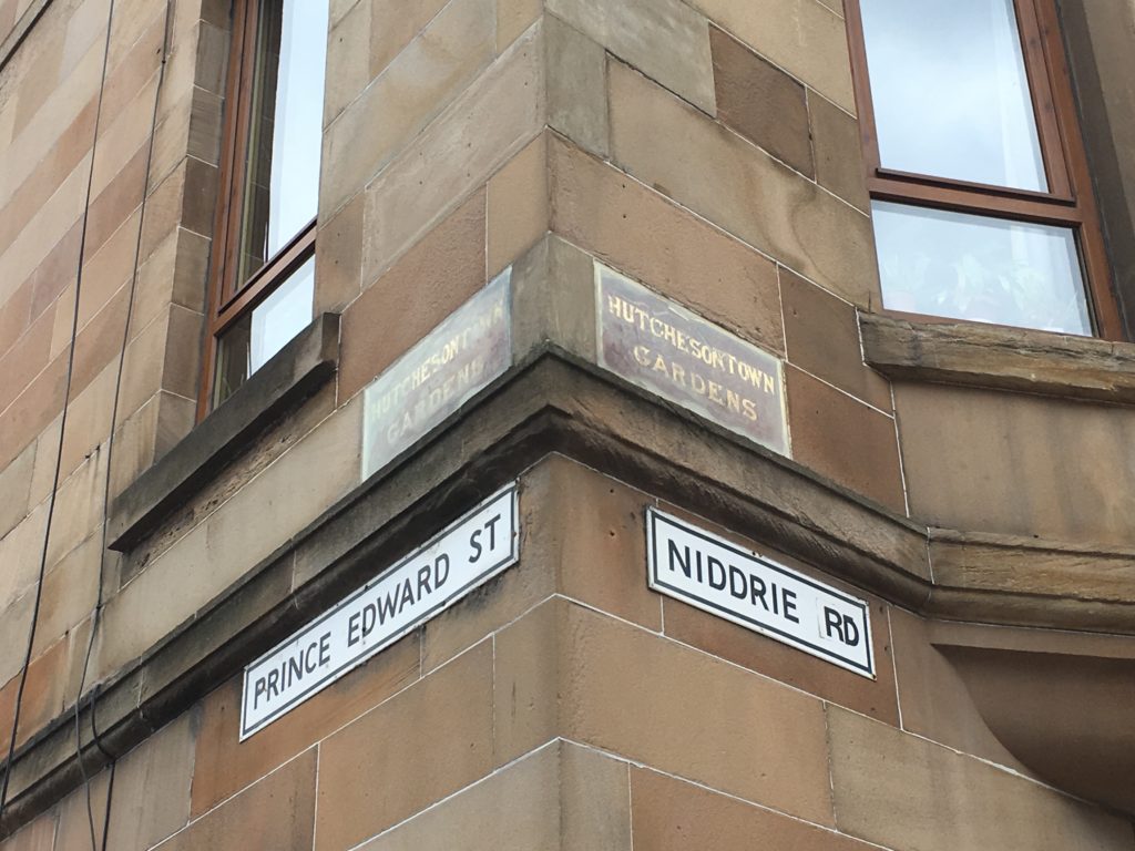
The new tenement block built on the site along the south side of the newly formed Prince Edward Street was originally known as Hutchesontown Gardens ; you can still see this designation on the building, above the street name.
Crossmyloof
The Gardens looked again for a new home, settling on 7 acres south of Crossmyloof Station, between Shawmoss Road and the railway line, leased by Sir John Stirling-Maxwell for £7 an acre. The management was entirely voluntary, with no paid staff.

Huchesontown Gardens at Crossmyloof, with Curling Ponds opposite. OS Map 1892
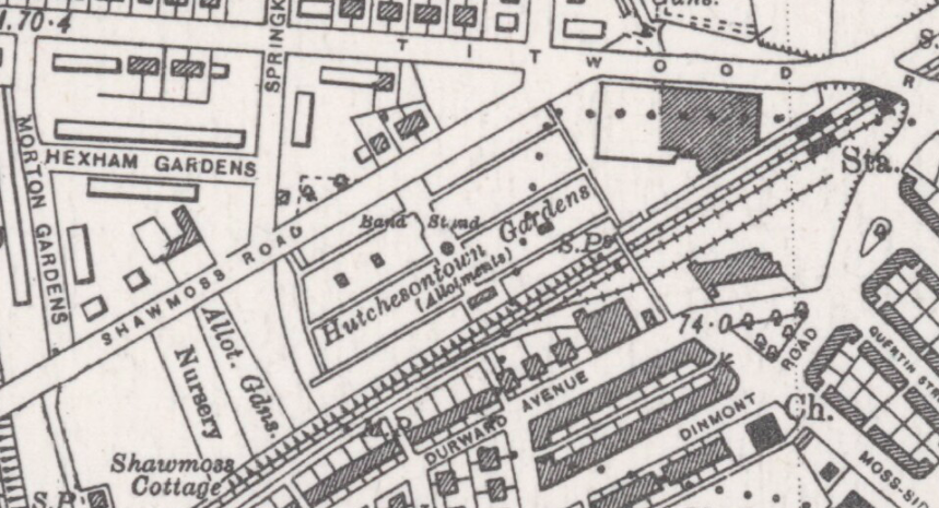
Hutchesontown Gardens Crossmyloof OS Map 1940
Note the bandstand centrally within the gardens.
The Gardens were eventually redeveloped in the 1960s into the Crossmyloof Gardens estate, between the ice rink (now Morrisons) and the scout hut and railway bridge.
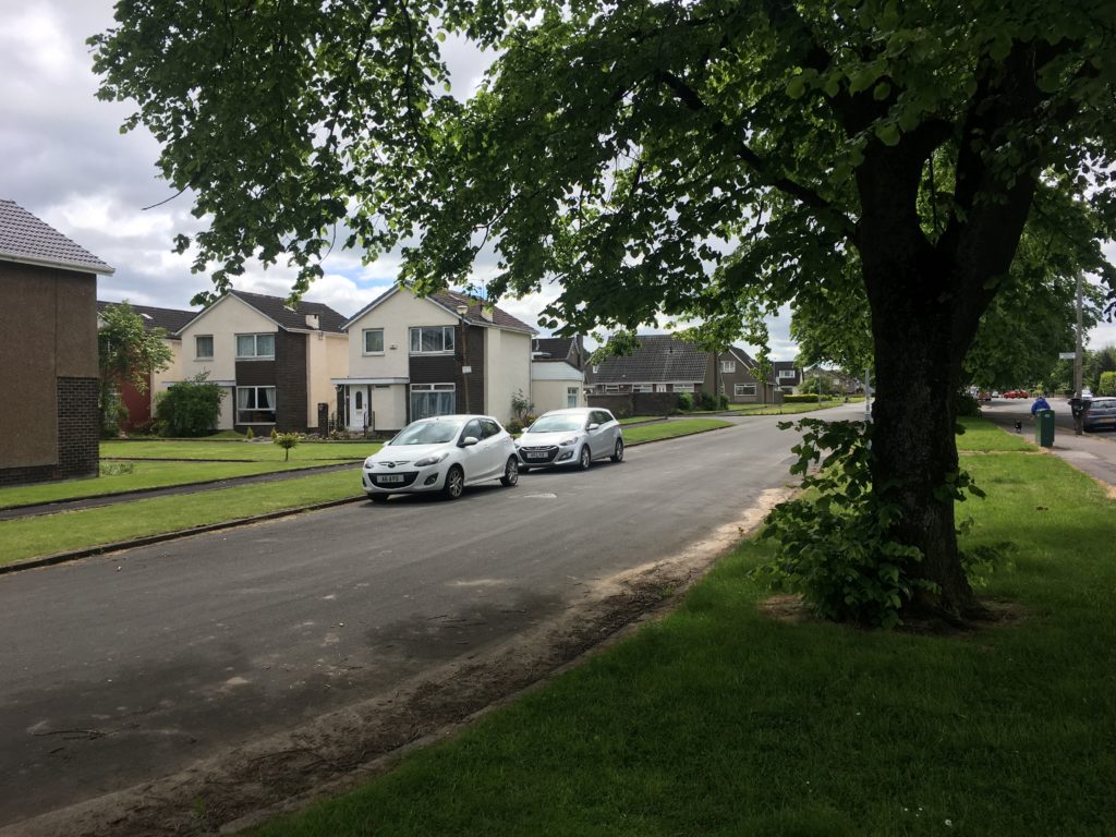
Crossmyloof Gardens 2019
Albert Gardens
Albert Gardens opened in 1854, east of the Southern Necropolis. They survived as Caledonia Gardens until 1961, when they succumbed to the wholesale regeneration of the Gorbals .
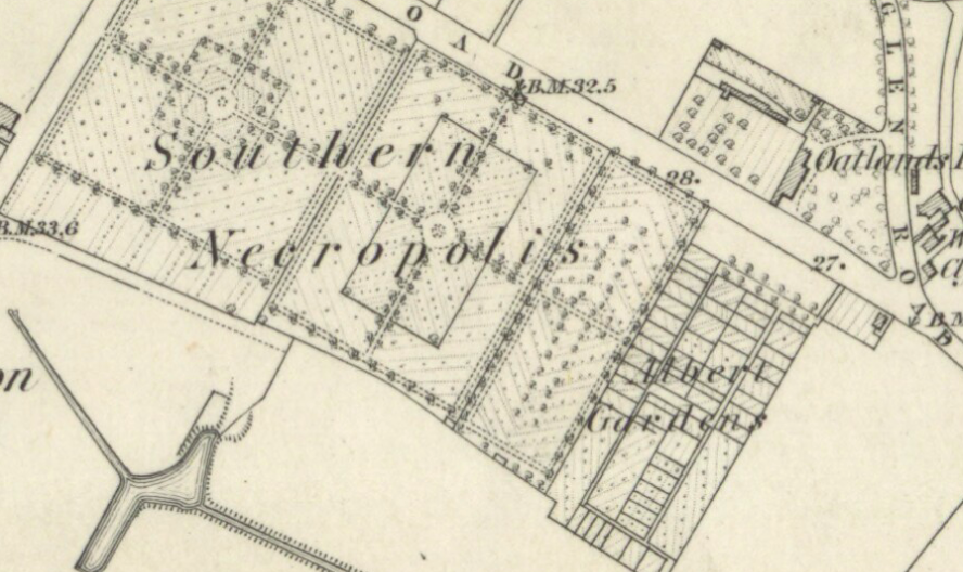
Albert Gardens, 1858

Caledonia Gardens, 1961, just before closure
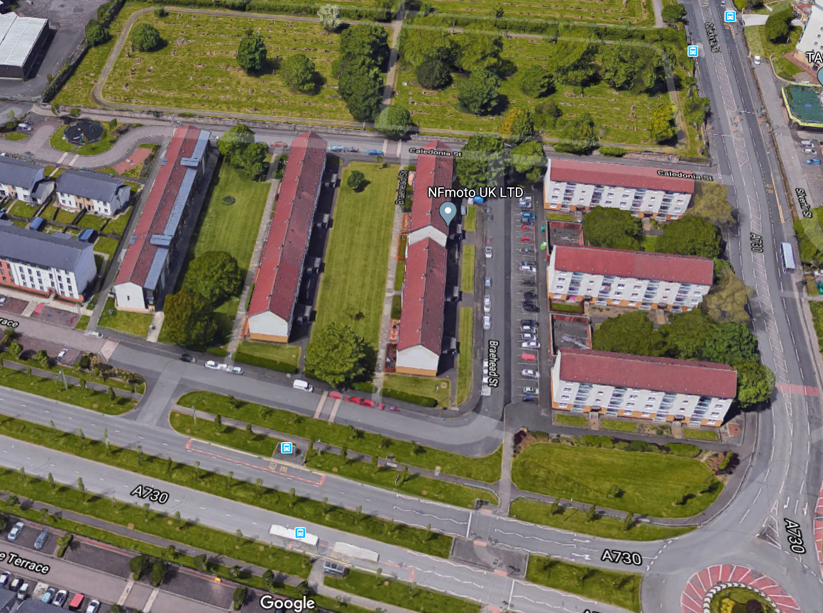
Site of Albert Gardens, Gorbals, Southern Necropolis behind
Victoria Gardens
Victoria Gardens began on the east side of Cathcart Road in Govanhill around 1865, but moved to Pollokshields in 1871. In 1878 they were reduced in size when Maxwell Road cut through the plot, but unlike the other garden allotments mentioned, New Victoria Gardens thrives to this day, and you can follow their activities on Facebook . If you want an allotment though, the current wait is 10 years. The Victorians knew what they were doing, and we could do with more such spaces.
The Hidden Gardens
A much more recent addition, on the site of the old Glasgow Tram Depot off Albert Drive, another place you can hone your horticultural skills.
Locavore and the Bellahouston Project
Quite by chance as I was about to post this, I came across Locavore’s proposal to take over from the council the disused nurseries in Bellahouston Park. Maybe these are the extra spaces we are looking for?
References
{3557955:4CIZCJQ5},{3557955:WEQ5BP8H};{3557955:VK4YBVKU};{3557955:WEQ5BP8H};{3557955:SGRFTCRK};{3557955:JT6LX8QU};{3557955:EE9884ZR};{3557955:LQGY6TTL};{3557955:XGVZ6VQU}
vancouver
asc
0
2111
%7B%22status%22%3A%22success%22%2C%22updateneeded%22%3Afalse%2C%22instance%22%3A%22zotpress-2fed6c9ecfd4a98f2bf3e0230a5c6b0f%22%2C%22meta%22%3A%7B%22request_last%22%3A0%2C%22request_next%22%3A0%2C%22used_cache%22%3Atrue%7D%2C%22data%22%3A%5B%7B%22key%22%3A%22LQGY6TTL%22%2C%22library%22%3A%7B%22id%22%3A3557955%7D%2C%22meta%22%3A%7B%22numChildren%22%3A0%7D%2C%22bib%22%3A%22%3Cdiv%20class%3D%5C%22csl-bib-body%5C%22%20style%3D%5C%22line-height%3A%201.35%3B%20%5C%22%3E%5Cn%20%20%3Cdiv%20class%3D%5C%22csl-entry%5C%22%20style%3D%5C%22clear%3A%20left%3B%20%5C%22%3E%5Cn%20%20%20%20%3Cdiv%20class%3D%5C%22csl-left-margin%5C%22%20style%3D%5C%22float%3A%20left%3B%20padding-right%3A%200.5em%3B%20text-align%3A%20right%3B%20width%3A%201em%3B%5C%22%3E1.%3C%5C%2Fdiv%3E%3Cdiv%20class%3D%5C%22csl-right-inline%5C%22%20style%3D%5C%22margin%3A%200%20.4em%200%201.5em%3B%5C%22%3ENew%20Victoria%20Gardens%20Association%20-%20Home%20%5BInternet%5D.%20%5Bcited%202019%20May%2023%5D.%20Available%20from%3A%20%3Ca%20href%3D%27https%3A%5C%2F%5C%2Fwww.facebook.com%5C%2FNewVictoriaGardensAssociation%5C%2F%27%3Ehttps%3A%5C%2F%5C%2Fwww.facebook.com%5C%2FNewVictoriaGardensAssociation%5C%2F%3C%5C%2Fa%3E%3C%5C%2Fdiv%3E%5Cn%20%20%3C%5C%2Fdiv%3E%5Cn%3C%5C%2Fdiv%3E%22%2C%22data%22%3A%7B%22itemType%22%3A%22webpage%22%2C%22title%22%3A%22New%20Victoria%20Gardens%20Association%20-%20Home%22%2C%22creators%22%3A%5B%5D%2C%22abstractNote%22%3A%22%22%2C%22date%22%3A%22%22%2C%22url%22%3A%22https%3A%5C%2F%5C%2Fwww.facebook.com%5C%2FNewVictoriaGardensAssociation%5C%2F%22%2C%22language%22%3A%22%22%2C%22collections%22%3A%5B%22CAR6MXPM%22%5D%2C%22dateModified%22%3A%222019-05-23T11%3A38%3A07Z%22%7D%7D%2C%7B%22key%22%3A%22EE9884ZR%22%2C%22library%22%3A%7B%22id%22%3A3557955%7D%2C%22meta%22%3A%7B%22numChildren%22%3A0%7D%2C%22bib%22%3A%22%3Cdiv%20class%3D%5C%22csl-bib-body%5C%22%20style%3D%5C%22line-height%3A%201.35%3B%20%5C%22%3E%5Cn%20%20%3Cdiv%20class%3D%5C%22csl-entry%5C%22%20style%3D%5C%22clear%3A%20left%3B%20%5C%22%3E%5Cn%20%20%20%20%3Cdiv%20class%3D%5C%22csl-left-margin%5C%22%20style%3D%5C%22float%3A%20left%3B%20padding-right%3A%200.5em%3B%20text-align%3A%20right%3B%20width%3A%201em%3B%5C%22%3E1.%3C%5C%2Fdiv%3E%3Cdiv%20class%3D%5C%22csl-right-inline%5C%22%20style%3D%5C%22margin%3A%200%20.4em%200%201.5em%3B%5C%22%3ELost%20Glasgow%20-%20Posts%20%5BInternet%5D.%20%5Bcited%202019%20May%2023%5D.%20Available%20from%3A%20%3Ca%20href%3D%27https%3A%5C%2F%5C%2Fwww.facebook.com%5C%2Flostglasgowofficial%5C%2Fposts%5C%2Fits-not-quite-the-good-life-nationalallotmentsweek-but-glasgows-victorian-teneme%5C%2F1604566166321900%5C%2F%27%3Ehttps%3A%5C%2F%5C%2Fwww.facebook.com%5C%2Flostglasgowofficial%5C%2Fposts%5C%2Fits-not-quite-the-good-life-nationalallotmentsweek-but-glasgows-victorian-teneme%5C%2F1604566166321900%5C%2F%3C%5C%2Fa%3E%3C%5C%2Fdiv%3E%5Cn%20%20%3C%5C%2Fdiv%3E%5Cn%3C%5C%2Fdiv%3E%22%2C%22data%22%3A%7B%22itemType%22%3A%22webpage%22%2C%22title%22%3A%22Lost%20Glasgow%20-%20Posts%22%2C%22creators%22%3A%5B%5D%2C%22abstractNote%22%3A%22%22%2C%22date%22%3A%22%22%2C%22url%22%3A%22https%3A%5C%2F%5C%2Fwww.facebook.com%5C%2Flostglasgowofficial%5C%2Fposts%5C%2Fits-not-quite-the-good-life-nationalallotmentsweek-but-glasgows-victorian-teneme%5C%2F1604566166321900%5C%2F%22%2C%22language%22%3A%22%22%2C%22collections%22%3A%5B%22CAR6MXPM%22%5D%2C%22dateModified%22%3A%222019-05-23T11%3A32%3A19Z%22%7D%7D%2C%7B%22key%22%3A%224CIZCJQ5%22%2C%22library%22%3A%7B%22id%22%3A3557955%7D%2C%22meta%22%3A%7B%22creatorSummary%22%3A%22Aird%22%2C%22parsedDate%22%3A%221894%22%2C%22numChildren%22%3A0%7D%2C%22bib%22%3A%22%3Cdiv%20class%3D%5C%22csl-bib-body%5C%22%20style%3D%5C%22line-height%3A%201.35%3B%20%5C%22%3E%5Cn%20%20%3Cdiv%20class%3D%5C%22csl-entry%5C%22%20style%3D%5C%22clear%3A%20left%3B%20%5C%22%3E%5Cn%20%20%20%20%3Cdiv%20class%3D%5C%22csl-left-margin%5C%22%20style%3D%5C%22float%3A%20left%3B%20padding-right%3A%200.5em%3B%20text-align%3A%20right%3B%20width%3A%201em%3B%5C%22%3E1.%3C%5C%2Fdiv%3E%3Cdiv%20class%3D%5C%22csl-right-inline%5C%22%20style%3D%5C%22margin%3A%200%20.4em%200%201.5em%3B%5C%22%3EAird%20AD.%20Glimpses%20of%20Old%20Glasgow%20%5BInternet%5D.%20Aird%20%26amp%3B%20Coghill%3B%201894.%20478%20p.%20Available%20from%3A%20%3Ca%20href%3D%27https%3A%5C%2F%5C%2Fwww.tradeshouselibrary.org%5C%2Fuploads%5C%2F4%5C%2F7%5C%2F7%5C%2F2%5C%2F47723681%5C%2Fglimpses_of_old_glasgow_~_aird_small.pdf%27%3Ehttps%3A%5C%2F%5C%2Fwww.tradeshouselibrary.org%5C%2Fuploads%5C%2F4%5C%2F7%5C%2F7%5C%2F2%5C%2F47723681%5C%2Fglimpses_of_old_glasgow_~_aird_small.pdf%3C%5C%2Fa%3E%3C%5C%2Fdiv%3E%5Cn%20%20%3C%5C%2Fdiv%3E%5Cn%3C%5C%2Fdiv%3E%22%2C%22data%22%3A%7B%22itemType%22%3A%22book%22%2C%22title%22%3A%22Glimpses%20of%20Old%20Glasgow%22%2C%22creators%22%3A%5B%7B%22creatorType%22%3A%22author%22%2C%22firstName%22%3A%22Andrew%20D%22%2C%22lastName%22%3A%22Aird%22%7D%5D%2C%22abstractNote%22%3A%22%22%2C%22date%22%3A%221894%22%2C%22language%22%3A%22%22%2C%22ISBN%22%3A%22%22%2C%22url%22%3A%22https%3A%5C%2F%5C%2Fwww.tradeshouselibrary.org%5C%2Fuploads%5C%2F4%5C%2F7%5C%2F7%5C%2F2%5C%2F47723681%5C%2Fglimpses_of_old_glasgow_~_aird_small.pdf%22%2C%22collections%22%3A%5B%22CAR6MXPM%22%5D%2C%22dateModified%22%3A%222019-05-23T11%3A17%3A57Z%22%7D%7D%2C%7B%22key%22%3A%22VK4YBVKU%22%2C%22library%22%3A%7B%22id%22%3A3557955%7D%2C%22meta%22%3A%7B%22numChildren%22%3A0%7D%2C%22bib%22%3A%22%3Cdiv%20class%3D%5C%22csl-bib-body%5C%22%20style%3D%5C%22line-height%3A%201.35%3B%20%5C%22%3E%5Cn%20%20%3Cdiv%20class%3D%5C%22csl-entry%5C%22%20style%3D%5C%22clear%3A%20left%3B%20%5C%22%3E%5Cn%20%20%20%20%3Cdiv%20class%3D%5C%22csl-left-margin%5C%22%20style%3D%5C%22float%3A%20left%3B%20padding-right%3A%200.5em%3B%20text-align%3A%20right%3B%20width%3A%201em%3B%5C%22%3E1.%3C%5C%2Fdiv%3E%3Cdiv%20class%3D%5C%22csl-right-inline%5C%22%20style%3D%5C%22margin%3A%200%20.4em%200%201.5em%3B%5C%22%3EThe%20Glasgow%20Herald%20-%20Google%20News%20Archive%2010%20August%201866%20%5BInternet%5D.%20%5Bcited%202019%20May%2023%5D.%20Available%20from%3A%20%3Ca%20href%3D%27https%3A%5C%2F%5C%2Fnews.google.com%5C%2Fnewspapers%3Fnid%3DGGgVawPscysC%26dat%3D18660810%26printsec%3Dfrontpage%26hl%3Den%27%3Ehttps%3A%5C%2F%5C%2Fnews.google.com%5C%2Fnewspapers%3Fnid%3DGGgVawPscysC%26dat%3D18660810%26printsec%3Dfrontpage%26hl%3Den%3C%5C%2Fa%3E%3C%5C%2Fdiv%3E%5Cn%20%20%3C%5C%2Fdiv%3E%5Cn%3C%5C%2Fdiv%3E%22%2C%22data%22%3A%7B%22itemType%22%3A%22webpage%22%2C%22title%22%3A%22The%20Glasgow%20Herald%20-%20Google%20News%20Archive%2010%20August%201866%22%2C%22creators%22%3A%5B%5D%2C%22abstractNote%22%3A%22%22%2C%22date%22%3A%22%22%2C%22url%22%3A%22https%3A%5C%2F%5C%2Fnews.google.com%5C%2Fnewspapers%3Fnid%3DGGgVawPscysC%26dat%3D18660810%26printsec%3Dfrontpage%26hl%3Den%22%2C%22language%22%3A%22%22%2C%22collections%22%3A%5B%22CAR6MXPM%22%5D%2C%22dateModified%22%3A%222019-05-23T10%3A55%3A47Z%22%7D%7D%2C%7B%22key%22%3A%22SGRFTCRK%22%2C%22library%22%3A%7B%22id%22%3A3557955%7D%2C%22meta%22%3A%7B%22numChildren%22%3A0%7D%2C%22bib%22%3A%22%3Cdiv%20class%3D%5C%22csl-bib-body%5C%22%20style%3D%5C%22line-height%3A%201.35%3B%20%5C%22%3E%5Cn%20%20%3Cdiv%20class%3D%5C%22csl-entry%5C%22%20style%3D%5C%22clear%3A%20left%3B%20%5C%22%3E%5Cn%20%20%20%20%3Cdiv%20class%3D%5C%22csl-left-margin%5C%22%20style%3D%5C%22float%3A%20left%3B%20padding-right%3A%200.5em%3B%20text-align%3A%20right%3B%20width%3A%201em%3B%5C%22%3E1.%3C%5C%2Fdiv%3E%3Cdiv%20class%3D%5C%22csl-right-inline%5C%22%20style%3D%5C%22margin%3A%200%20.4em%200%201.5em%3B%5C%22%3EVirtual%20Mitchell%20%7C%20Torrisdale%20street%20%5BInternet%5D.%20%5Bcited%202019%20May%2023%5D.%20Available%20from%3A%20%3Ca%20href%3D%27http%3A%5C%2F%5C%2Fwww.mitchelllibrary.org%5C%2Fvirtualmitchell%5C%2Findex.php%3Fa%3Dwordsearch%26s%3Ditem%26key%3DWczoxMDoidG9ycmlzZGFsZSI7%26pg%3D2%27%3Ehttp%3A%5C%2F%5C%2Fwww.mitchelllibrary.org%5C%2Fvirtualmitchell%5C%2Findex.php%3Fa%3Dwordsearch%26s%3Ditem%26key%3DWczoxMDoidG9ycmlzZGFsZSI7%26pg%3D2%3C%5C%2Fa%3E%3C%5C%2Fdiv%3E%5Cn%20%20%3C%5C%2Fdiv%3E%5Cn%3C%5C%2Fdiv%3E%22%2C%22data%22%3A%7B%22itemType%22%3A%22webpage%22%2C%22title%22%3A%22Virtual%20Mitchell%20%7C%20Torrisdale%20street%22%2C%22creators%22%3A%5B%5D%2C%22abstractNote%22%3A%22%22%2C%22date%22%3A%22%22%2C%22url%22%3A%22http%3A%5C%2F%5C%2Fwww.mitchelllibrary.org%5C%2Fvirtualmitchell%5C%2Findex.php%3Fa%3Dwordsearch%26s%3Ditem%26key%3DWczoxMDoidG9ycmlzZGFsZSI7%26pg%3D2%22%2C%22language%22%3A%22%22%2C%22collections%22%3A%5B%22CAR6MXPM%22%5D%2C%22dateModified%22%3A%222019-05-23T10%3A23%3A32Z%22%7D%7D%2C%7B%22key%22%3A%22JT6LX8QU%22%2C%22library%22%3A%7B%22id%22%3A3557955%7D%2C%22meta%22%3A%7B%22creatorSummary%22%3A%22Glasgow%22%2C%22parsedDate%22%3A%222018-09-03%22%2C%22numChildren%22%3A1%7D%2C%22bib%22%3A%22%3Cdiv%20class%3D%5C%22csl-bib-body%5C%22%20style%3D%5C%22line-height%3A%201.35%3B%20%5C%22%3E%5Cn%20%20%3Cdiv%20class%3D%5C%22csl-entry%5C%22%20style%3D%5C%22clear%3A%20left%3B%20%5C%22%3E%5Cn%20%20%20%20%3Cdiv%20class%3D%5C%22csl-left-margin%5C%22%20style%3D%5C%22float%3A%20left%3B%20padding-right%3A%200.5em%3B%20text-align%3A%20right%3B%20width%3A%201em%3B%5C%22%3E1.%3C%5C%2Fdiv%3E%3Cdiv%20class%3D%5C%22csl-right-inline%5C%22%20style%3D%5C%22margin%3A%200%20.4em%200%201.5em%3B%5C%22%3EGlasgow%20P.%20Tenements%20under%20construction%20at%20Hutchesontown%20Gardens%20at%20the%20corner%20of%20Prince%20Edward%20St%20and%20Cromwell%20Rd%20%28latterly%20Niddrie%20Rd%29%20in%201896.pic.twitter.com%5C%2FbU3NQ3SvN1%20%5BInternet%5D.%20%40pastglasgow.%202018%20%5Bcited%202019%20May%2023%5D.%20Available%20from%3A%20%3Ca%20href%3D%27https%3A%5C%2F%5C%2Ftwitter.com%5C%2Fpastglasgow%5C%2Fstatus%5C%2F1036728677407567872%3Flang%3Den%27%3Ehttps%3A%5C%2F%5C%2Ftwitter.com%5C%2Fpastglasgow%5C%2Fstatus%5C%2F1036728677407567872%3Flang%3Den%3C%5C%2Fa%3E%3C%5C%2Fdiv%3E%5Cn%20%20%3C%5C%2Fdiv%3E%5Cn%3C%5C%2Fdiv%3E%22%2C%22data%22%3A%7B%22itemType%22%3A%22blogPost%22%2C%22title%22%3A%22Tenements%20under%20construction%20at%20Hutchesontown%20Gardens%20at%20the%20corner%20of%20Prince%20Edward%20St%20and%20Cromwell%20Rd%20%28latterly%20Niddrie%20Rd%29%20in%201896.pic.twitter.com%5C%2FbU3NQ3SvN1%22%2C%22creators%22%3A%5B%7B%22creatorType%22%3A%22author%22%2C%22firstName%22%3A%22Past%22%2C%22lastName%22%3A%22Glasgow%22%7D%5D%2C%22abstractNote%22%3A%22%22%2C%22blogTitle%22%3A%22%40pastglasgow%22%2C%22date%22%3A%222018-09-03T14%3A32%22%2C%22url%22%3A%22https%3A%5C%2F%5C%2Ftwitter.com%5C%2Fpastglasgow%5C%2Fstatus%5C%2F1036728677407567872%3Flang%3Den%22%2C%22language%22%3A%22en%22%2C%22collections%22%3A%5B%22CAR6MXPM%22%5D%2C%22dateModified%22%3A%222019-05-23T10%3A17%3A31Z%22%7D%7D%2C%7B%22key%22%3A%22XGVZ6VQU%22%2C%22library%22%3A%7B%22id%22%3A3557955%7D%2C%22meta%22%3A%7B%22parsedDate%22%3A%222019-05-21%22%2C%22numChildren%22%3A1%7D%2C%22bib%22%3A%22%3Cdiv%20class%3D%5C%22csl-bib-body%5C%22%20style%3D%5C%22line-height%3A%201.35%3B%20%5C%22%3E%5Cn%20%20%3Cdiv%20class%3D%5C%22csl-entry%5C%22%20style%3D%5C%22clear%3A%20left%3B%20%5C%22%3E%5Cn%20%20%20%20%3Cdiv%20class%3D%5C%22csl-left-margin%5C%22%20style%3D%5C%22float%3A%20left%3B%20padding-right%3A%200.5em%3B%20text-align%3A%20right%3B%20width%3A%201em%3B%5C%22%3E1.%3C%5C%2Fdiv%3E%3Cdiv%20class%3D%5C%22csl-right-inline%5C%22%20style%3D%5C%22margin%3A%200%20.4em%200%201.5em%3B%5C%22%3EBellahouston%20Project%20%5BInternet%5D.%20Locavore.%202019%20%5Bcited%202019%20May%2023%5D.%20Available%20from%3A%20%3Ca%20href%3D%27https%3A%5C%2F%5C%2Fglasgowlocavore.org%5C%2Fbellahouston-project%5C%2F%27%3Ehttps%3A%5C%2F%5C%2Fglasgowlocavore.org%5C%2Fbellahouston-project%5C%2F%3C%5C%2Fa%3E%3C%5C%2Fdiv%3E%5Cn%20%20%3C%5C%2Fdiv%3E%5Cn%3C%5C%2Fdiv%3E%22%2C%22data%22%3A%7B%22itemType%22%3A%22blogPost%22%2C%22title%22%3A%22Bellahouston%20Project%22%2C%22creators%22%3A%5B%5D%2C%22abstractNote%22%3A%22PLEDGE%20YOUR%20SUPPORT%21%20We%5Cu2019re%20excited%20to%20let%20you%20know%20about%20our%20newest%20project%3A%20We%5Cu2019re%20planning%20to%20transform%20a%20closed-down%20council%20plant%20nursery%20into%20a%20productive%20organic%20food%20growing%20project%20in%20the%20so%5Cu2026%22%2C%22blogTitle%22%3A%22Locavore%22%2C%22date%22%3A%222019-05-21T14%3A41%3A58%2B00%3A00%22%2C%22url%22%3A%22https%3A%5C%2F%5C%2Fglasgowlocavore.org%5C%2Fbellahouston-project%5C%2F%22%2C%22language%22%3A%22en-GB%22%2C%22collections%22%3A%5B%22CAR6MXPM%22%5D%2C%22dateModified%22%3A%222019-05-23T10%3A12%3A30Z%22%7D%7D%2C%7B%22key%22%3A%22WEQ5BP8H%22%2C%22library%22%3A%7B%22id%22%3A3557955%7D%2C%22meta%22%3A%7B%22creatorSummary%22%3A%22Munro%22%2C%22parsedDate%22%3A%221933%22%2C%22numChildren%22%3A0%7D%2C%22bib%22%3A%22%3Cdiv%20class%3D%5C%22csl-bib-body%5C%22%20style%3D%5C%22line-height%3A%201.35%3B%20%5C%22%3E%5Cn%20%20%3Cdiv%20class%3D%5C%22csl-entry%5C%22%20style%3D%5C%22clear%3A%20left%3B%20%5C%22%3E%5Cn%20%20%20%20%3Cdiv%20class%3D%5C%22csl-left-margin%5C%22%20style%3D%5C%22float%3A%20left%3B%20padding-right%3A%200.5em%3B%20text-align%3A%20right%3B%20width%3A%201em%3B%5C%22%3E1.%3C%5C%2Fdiv%3E%3Cdiv%20class%3D%5C%22csl-right-inline%5C%22%20style%3D%5C%22margin%3A%200%20.4em%200%201.5em%3B%5C%22%3EMunro%20JM.%20Strathbungo%20and%20its%20Kirk%201833-1933%20%5BInternet%5D.%20Glasgow%3A%20Aird%20%26amp%3B%20Coghill%20Ltd%3B%201933.%20Available%20from%3A%20%3Ca%20href%3D%27http%3A%5C%2F%5C%2Fbygone.bungoblog.com%5C%2Fwp%5C%2Fwp-content%5C%2Fuploads%5C%2FStrathbungo-and-its-Kirk-1833-1933.pdf%27%3Ehttp%3A%5C%2F%5C%2Fbygone.bungoblog.com%5C%2Fwp%5C%2Fwp-content%5C%2Fuploads%5C%2FStrathbungo-and-its-Kirk-1833-1933.pdf%3C%5C%2Fa%3E%3C%5C%2Fdiv%3E%5Cn%20%20%3C%5C%2Fdiv%3E%5Cn%3C%5C%2Fdiv%3E%22%2C%22data%22%3A%7B%22itemType%22%3A%22book%22%2C%22title%22%3A%22Strathbungo%20and%20its%20Kirk%201833-1933%22%2C%22creators%22%3A%5B%7B%22creatorType%22%3A%22author%22%2C%22firstName%22%3A%22John%20M%22%2C%22lastName%22%3A%22Munro%22%7D%5D%2C%22abstractNote%22%3A%22%22%2C%22date%22%3A%221933%22%2C%22language%22%3A%22%22%2C%22ISBN%22%3A%22%22%2C%22url%22%3A%22http%3A%5C%2F%5C%2Fbygone.bungoblog.com%5C%2Fwp%5C%2Fwp-content%5C%2Fuploads%5C%2FStrathbungo-and-its-Kirk-1833-1933.pdf%22%2C%22collections%22%3A%5B%22CAR6MXPM%22%5D%2C%22dateModified%22%3A%222017-02-02T17%3A09%3A15Z%22%7D%7D%5D%7D
Like this:
Like Loading...


August 21, 2019 at 6:28 pm
What was the obscure jazz CD called? I’m intrigued.
August 21, 2019 at 8:59 pm
Now you’re just being difficult…
A Schlep from Strathbungo by Ivor Kallin & John Bisset.
https://www.discogs.com/Ivor-Kallin-John-Bisset-A-Schlep-From-Strathbungo/release/1450867
https://www.thetimes.co.uk/article/ivor-kallinjohn-bisset-a-schlep-from-strathbungo-the-sunday-times-review-kjnt776hkts
£25 on Amazon. Happy listening if you can find it; come back with a review.
January 6, 2022 at 4:22 pm
I was born at 30 Nithsdale Street in 1944 and moved to England to be with my father’s family in London after the war. My father passed away in 1947 and in 1949 we moved to Mansfield in Nottinghamshire to live with my mum’s parents who had moved there from Glasgow. My aunt and her family remained at 30 Nithsdale Street and for the next 10 years or so I would spend every summer with them. My birth was registered in Strathbungo and my first Post Office savings book in Crosshill. These blogs and in particular bring many locations and street names to mind and the memories of those Summer holidays come flooding back. Football with my cousins pals on the back greens, Calder Street Baths, Queens Park, fresh baked breakfast rolls from a nearby bakery, the trams that would shake you out of bed in the early morning etc. etc.
Thank you all for your contributions.
January 6, 2022 at 10:10 pm
30 Nithsdale Street is listed here, part of Salisbury Crescent. Don’t see any Barhams, but happy to add a few more former residents if you wish!
January 6, 2022 at 10:22 pm
My Grandparents would have been the named tenants at the time under the name of Horn and when they moved to Mansfield in 1949/50 my mother’s sister and her husband acquired the tenancy under the name Butler. My mum’s maiden name was Horn her married name Barham and as there would have been no census records until 1951 her surname of Barham would not have appeared. At the time my father would not have been resident at 30 Nithsdale Street as he was serving in the army.
Hope this makes sense !
January 7, 2022 at 2:40 pm
Have located my Grandfather (J. R. Horn) registered as residing at 30 Nithsdale Street in 1939. Thanks.
January 7, 2022 at 8:27 pm
Result!