
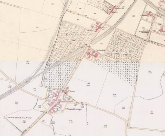
In the previous article we saw how Strathbungo, or Marchtown, began to appear on early maps of Glasgow, Renfrewshire and Lanarkshire. We ended with the first detailed OS map of the village, reproduced again here. Surveyed in 1858, this was after the construction of the railway line to Barrhead, to the west, but just before the redevelopment of Strathbungo as a suburb of Glasgow.

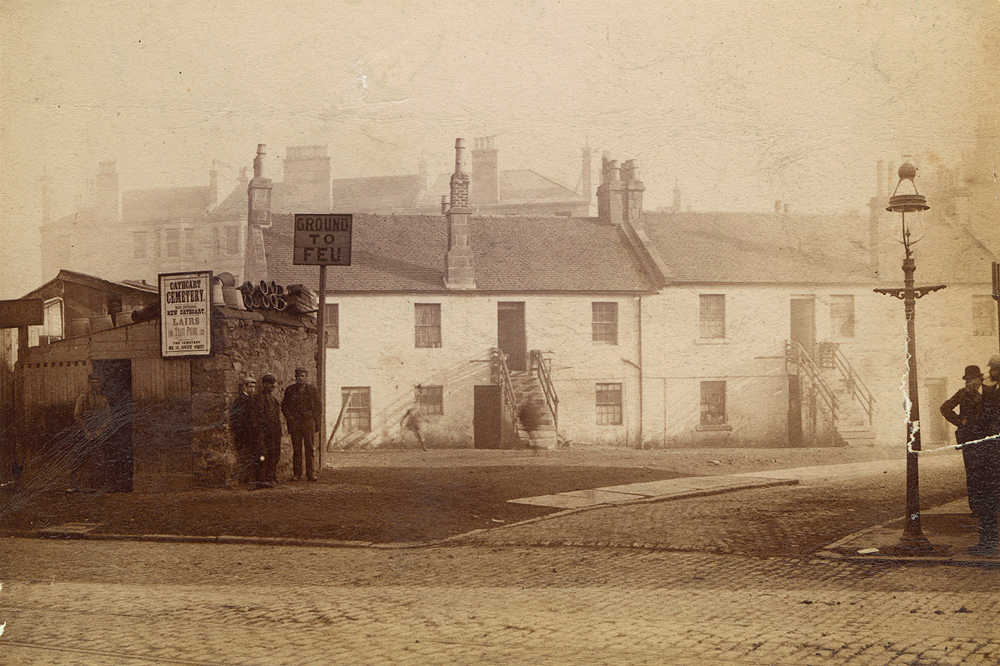
On the map the parish church lies to the north, within the village boundary (marked in yellow), but just north of the Renfrewshire-Lanarkshire border (dashed black line). The school is on the site of what is now March Street to the west. Weavers’ cottages are set back from the road on the south east plot – the Duncan Brown photograph below shows these cottages still there 30 years later. Plot 1790, the field to the east of the weavers’ cottages, became Hutchesontown Gardens, until the Cathcart Circle line was cut through the village, and Queens Park Station opened there in 1886.
Strathbungo Village in the 1890s
The 1850s marked the start of a period of major development and building in the area, changing Strathbungo for ever. The land to the south west of the village belonged to Sir John Maxwell, but was cut off from his estate by the new railway line. This was ripe for development, and a feuing plan was prepared for a series of villas, below.
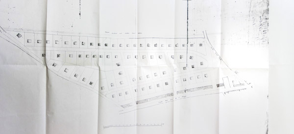
Moray Place feu plan 1858
In 1859 a more familiar feuing plan was drawn up, with more dense terraced housing on a grid of streets. For more detail on the development of the Strathbungo suburb, also known as Regents Park, see the article From Regents Park to modern Strathbungo.

1859 Strathbungo Feuing Plan – click to enlarge

Note how consistent the feuing plan is with what was actually built (above). Note Shiels Road became Nithsdale Road, Matilda Terrace became Nithsdale Street, although the name lived on in the tenement on the south side of the street for a while, and Carswell Gardens was originally to be Afton Place. The plans proposed a new alignment of the road to Shawmoss Farm, i.e. Titwood Road, though this didn’t happen until the 1920s.
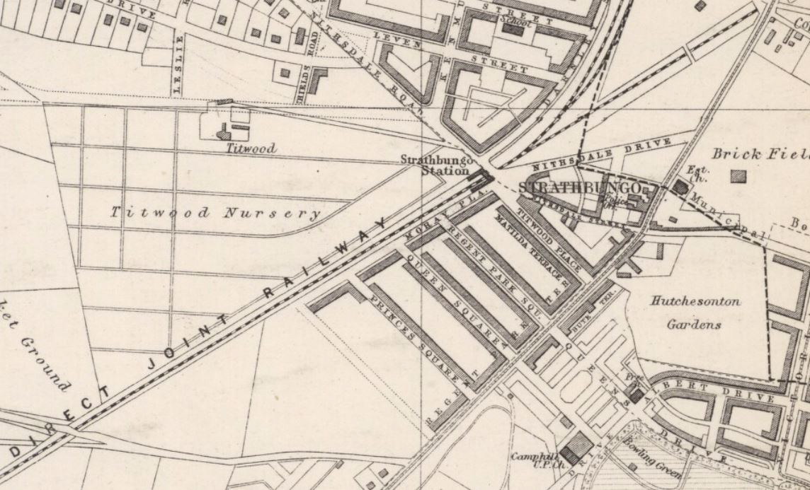
In 1870, the Glasgow PO Directory included a map showing the progress of building. The first two terraces in Moray Place had been built, along with Daniel McNicol’s Georgian terraces on Regent Park Square and the north side of Queen Square. All four of the Regent Park Terrace tenements on Pollokshaws Road were complete; the last block had only been occupied the previous year. The Titwood Brick Works is still present on land which would eventually become Marywood Square. Note there is also no Darnley Road, no Strathbungo Railway Station, and no Cathcart Circle. East Pollokshields is being laid out, but Titwood Farm is still present. Queens Park has been laid out, but doesn’t yet extend to include Camp Hill. Crosshill is a new focus of tenenment building beside the park gates, encouraged by the new park. New Hutchesontown Gardens is still beside Butterbiggins Road, but will move to the vacant space east of Strathbungo village in 1876.

1870 PO Directory Map
By the time of the 1882 Glasgow Directory, all four Victorian terraces on Moray Place are complete, as are the terraces on the south side of Queen Square, and north side of Prince’s Square (later Marywood Square). New also are Matilda Terrace and Titwood Place (the tenements of Nithsdale Street), Bute Terrace (the tenements on the east side of Pollokshaws Road), and the Camphill U.P. (now Baptist) and Free (now C of S) Churches beside Queen’s Park. Strathbungo Station has now opened, Hutchesontown Gardens have moved to the vacant space east of the village, and the Austin & McAslan Nursery has moved to the land of Titwood Farm. Most of the ring of Salisbury Quadrant and the adjacent tenements round on to March Street (including the Police Station on March St) are completed; just one block on the newly laid Nithsdale Drive is missing. Note how the corner of Nithsdale Drive and March Street falls in Lanarkshire; it belonged to the City of Glasgow and not to Sir John Maxwell. He tried to buy it to complete the ring of tenements, but failed, and hence this corner remained vacant, and was used as a yard by Glasgow Corporation, and latterly the Southern Cylinder Grinding Co. It was only completed in the 21st century, when Southside Housing Association built on the site.
Map by John Bartholomew for the PO Directory of 1882
By 1896 the layout is more familiar – all the Victorian terraces of Strathbungo are complete, though building then stalled for over 40 years before the feuing plan was completed with the building of the gardens. Much of Pollokshields is now built, though still no Darnley Road. There are two new churches on Glencairn Drive, though neither has survived. The Cathcart Circle is complete, and there is a wide choice of alternative churches on or around Queens Drive; Baptist, Swedenborgian, Free and United Presbyterian, in addition to Strathbungo’s own, expanded, parish church of 1888 on the main road.

1896 OS 25 inch map Strathbungo – click to open and enlarge for more detail
The Valuation Rolls of 1913 were accompanied by a map showing Strathbungo within Pollokshields Ward. It shows how Darnley Gardens was originally named Shawmoss Road, and it was intended for it to continue straight through the former nursery, what is now Hutcheson Grammar School’s playing fields, to join its namesake across Titwood Road. When this didn’t happen, at some point Shawmoss Road was eventually renamed to Darnley Gardens, and Darnley Gardens to Darnley Place – the new names appear on the 1953 OS Maps.

The Chapel of Ease on Glencairn Drive has been replaced by tenements, and the UP Church has been joined by Titwood Parish Church next door, on the high ground next to the Queens Park Tennis Club. The former burnt down in 1988, and only the east doorway survives, while the latter church was taken down stone by stone and moved to Pollok in the 1950s, where it still stands as St James’.
Development of Strathbungo didn’t resume until after the Great War, starting with the realignment of the former private road to Shawmoss Farm, Titwood Road. The road was moved northwards, allowing space for further housing and industrial units on the south side of the road; this can be seen in the differences between the Bartholomew Glasgow maps of 1920-21 and 1922.
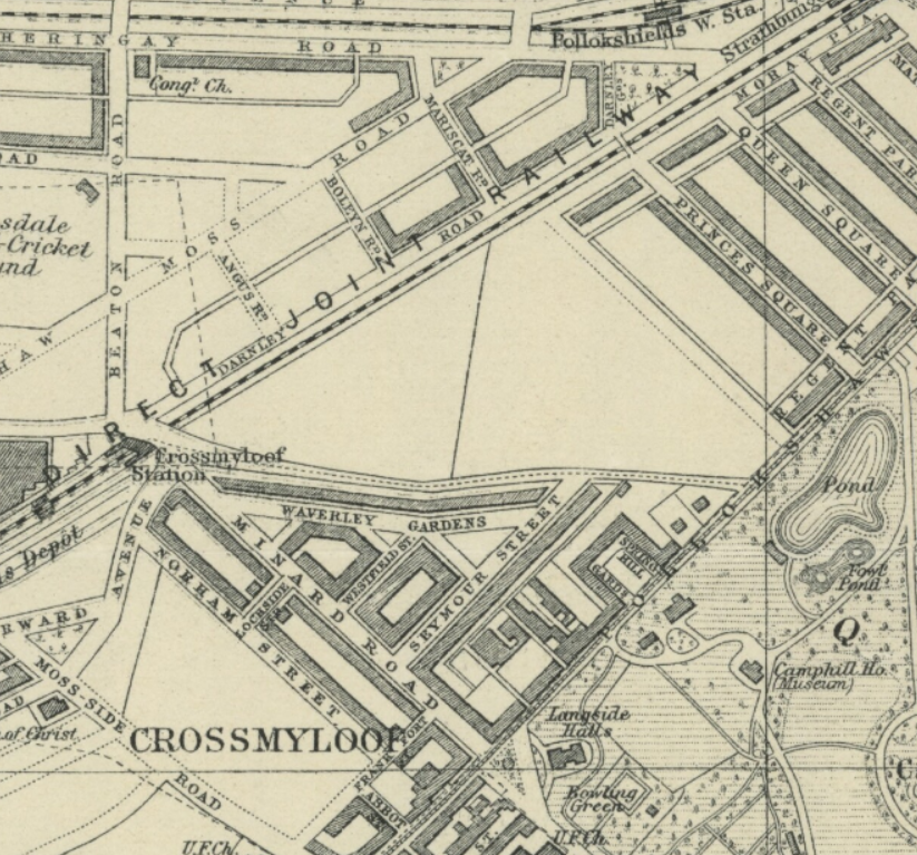
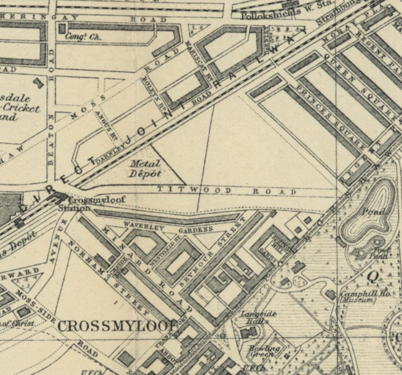

Lane off Waverley Street
The short lane off Waverley Street is all that remains of the old Titwood Road.
On the OS maps of 1934-35 we see the final result, with the addition of Vennard, Thorncliffe and Carswell Gardens. The south side of Carswell Gardens were added to a different design, as this land, although Maxwell land, was sold under a different feu. The plot behind became a Glasgow Corporation depot for many years, before the construction of the present day Crossmyloof Resource Centre and residential home. In 2020 this plot is about to be offered for sale again, for residential development – one final expansion of the Strathbungo suburb?
In 1938 Strathbungo was apparently briefly relocated to India, as illustrated on the edge of the map of the Empire Exhibition in Bellahouston Park.

The Empire Exhibition 1938
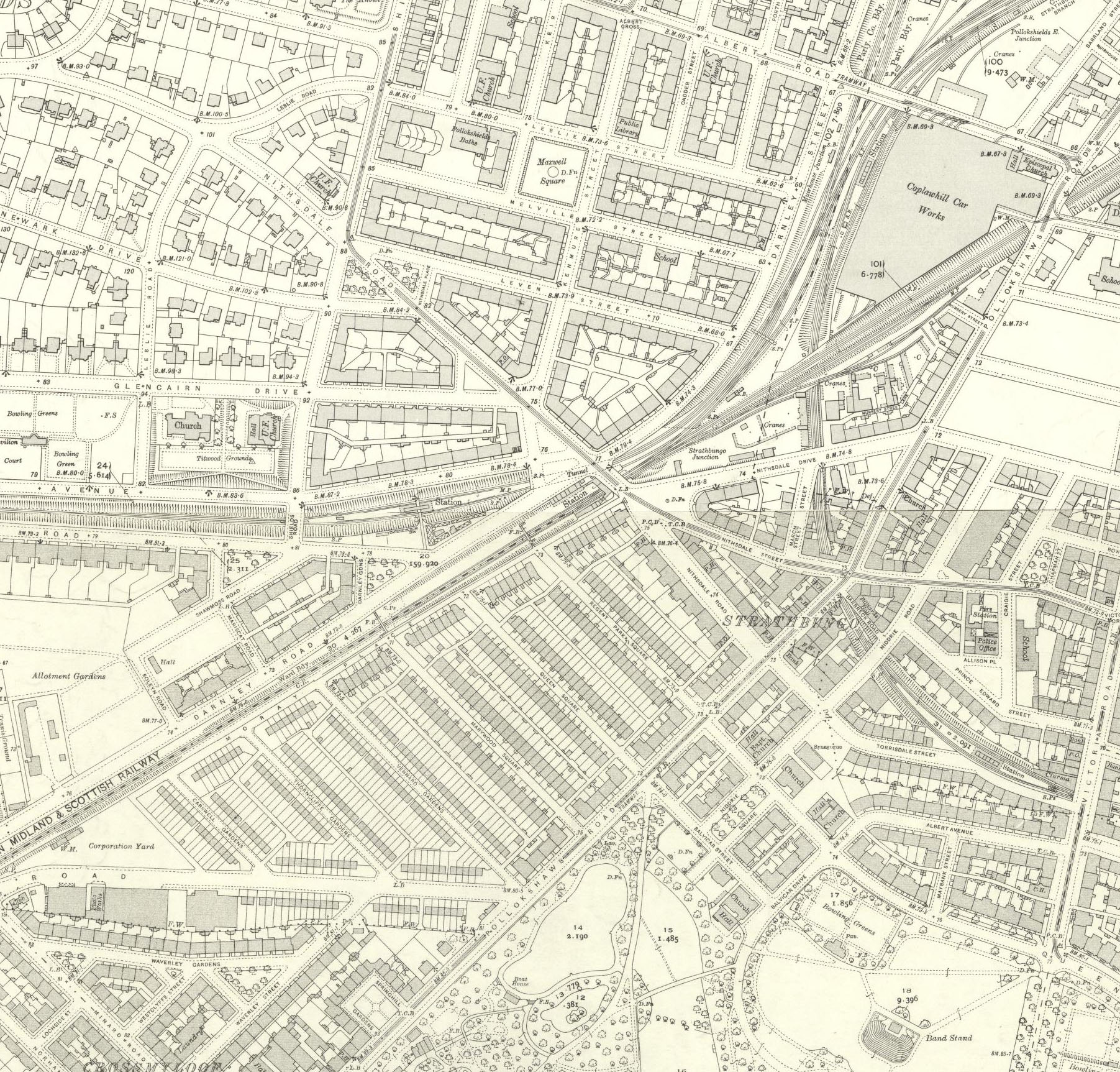
The 1951 1:1250 scale OS Maps are beautifully detailed and worthy of closer exploration, but they are so large it takes several to cover all of Strathbungo. Heres a sample:

1951 OS Map
Visit NLS maps to explore these more.
Our final map is more what might have been – the plans for the South Link motorway that was to plow under the duckpond and Pollokshaws Road and through the Gardens, devastating much of Strathbungo. The whole story is told in another article, The motorway that nearly killed Strathbungo.. Although eventually abandoned, it led to the formation of the Strathbungo Society. And oddly it did come to fruition eventually – the Shieldhall Tunnel sewer, big enough to take a bus, opened in 2018 and follows the same route, under the duckpond and down Titwood Road . Fortunately you wouldn’t notice at ground level.

South Link, central section, Strathbungo & Queens Park
The maps on this page are reproduced with the permission of the National Library of Scotland . Their site includes a fascinating range of historical maps you can explore on line and is well worth a visit.
Recent Comments