
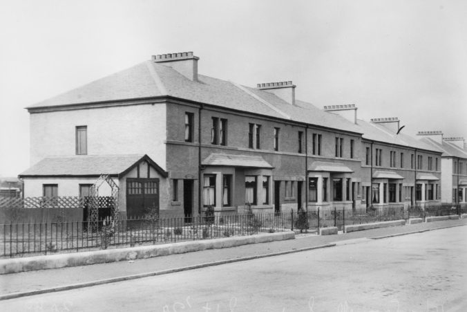
Wandering around Strathbungo, I often wondered why the houses on the south side of Carswell Gardens were different from all the others – a different design, and painted white rather than built in sandstone. Investigating further, with the help of documents from a couple of residents, I have found the answer:
They aren’t actually part of Strathbungo at all.
Before I cause any political upset down that end of the Bungo, I had better explain.
The Regents Park development
As is well documented elsewhere on this site, in 1859-1860 Sir John Maxwell of Pollok sold a parcel of his land that had been cut off by the railway line for development for housing. It was purchased by John McIntyre, builder, and William Stevenson, quarryman, with a view to building a Victorian suburb to be called Regents Park. As is well known, they asked Alexander “Greek” Thomson to build the first terrace, 1-10 Moray Place, and other builders purchased plots and built the squares, and the terraces on Pollokshaws Road. Building slowed however, and after the completion of Princes Square (now Marywood Square) in 1888, it ceased. Even maps of the 1920s show the remainder of the plot to be empty.
It was only forty years later, in the late 1920s, that building recommenced, when James Wright purchased the remainder of the land from the successors of McIntyre & Stevenson and built the red sandstone gardens in a 20th Century style. The official name Regents Park stuck well in to the 20th Century on some documents, but everyone called the area Strathbungo anyway, and the development is now synonymous with the name Strathbungo.
The original feuing plan for Regents Park of 1859 shows the planned layout of roads, and subsequent development stuck pretty rigidly to the plan; overlaying the plan on a modern map gives a very close match. The plan required the final street to be named Afton Place, and the land boundary was to run down the centre line. The remaining land up to Crossmyloof railway bridge also belonged to Maxwell, and presumably he intended to provide for and own the other half of the street. That street became Carswell Street when it was finally planned out, and Carswell Gardens when constructed.

1859 Strathbungo Feuing Plan – click to enlarge
Titwood Road
The other thing to note on the plan, and on old maps of the period, is the line of Titwood Road, marked “Private Road leading past Shawmoss Farm Steading” on the plan. This was a lane that ran from Pollokshaws Road over the railway line to Shawmoss Farm and the Titwood Coal Pits, continuing as Shawmoss Road. The land purchase included the road, which at that time ran from the southern edge of McMillan’s Bar & Chop House, along the boundary wall with the BP Garage (which at that time was two houses owned by the Wrights). The short back lane opposite Caldwell Wrights ironmongery is also part of the original Titwood Road. The plan was to re-align Titwood Road within the development, and so build on both sides of it. Map evidence suggests the re-alignment of Titwood Road was completed around 1922.

1859 feuing plan overlaid on Google Maps. Note the close match, except for Titwood Road. Click to enlarge.
Thus when James Wright was building his “Gardens” and completing the suburb of Strathbungo c.1928, the south side of Carswell Gardens was not on the land he had purchased. I can only assume there was some negotiation with the Maxwell estate to finally allow for the long planned realignment of Titwood Road, as this would have required some co-ordination. The road was moved further north, and Wright built three terraces on the other side of it, from Pollokshaws Road to opposite Carswell Gardens.
The change in location of Titwood Road can also be seen on the National Library of Scotland’s map overlay.
Aitkenhead’s houses
Meanwhile the Maxwells sold the other side of Carswell Gardens to a different developer, William Todd Aitkenhead. This plot also included part of the new Titwood Road, and so Aitkenhead built two pairs of semi-detached houses on the other side of Titwood Road, in addition to the two terraces on Carswell Gardens, to a different design from the rest of the gardens. Thus Aitkenhead’s white houses were not technically part of the original planned Strathbungo development.

Aitkenhead’s plans for Carswell Gardens, overlaid on 1859 feu, and Google Maps. Note the change in position of Titwood Road,
originally marked by the red boundary, bottom centre
No photographs exist of the Wrights’ villas on Pollokshaws Road, but this photograph shows one of the Wright brothers’ Pollokshaws Road site office, with the new houses on Titwood Road visible just behind. The old Titwood Road would have started to the left of the newsagent, but now starts well to the right. These shops were promptly replaced by a new motorcar showroom (also built on the original Strathbungo land purchase), and this building still survives as McMillan’s.
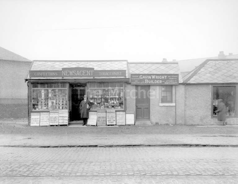
Wright Building Office, Pollokshaws Road at Titwood Road

The exact same view in 2015 (before McMillans was repainted)
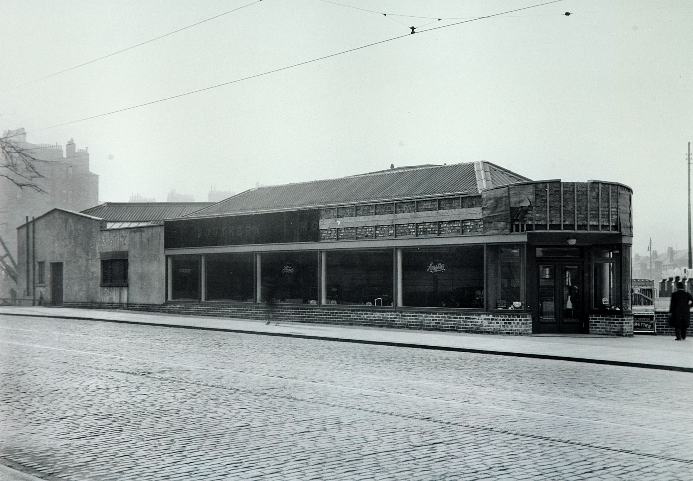
Southern Motors Garage, Pollokshaws Road at Titwood Road, shortly after construction c.1930, now McMillan’s
The nursing home
The remainder of the land up to Crossmyloof was presumably sold around the same time to the Corporation of Glasgow, for use as a maintenance depot – it is marked as such on Aitkenhead’s plans – and was later used to build the council run nursing home, Crossmyloof Resource Centre. The depot is seen on this 1960s photograph courtesy of John Robin .
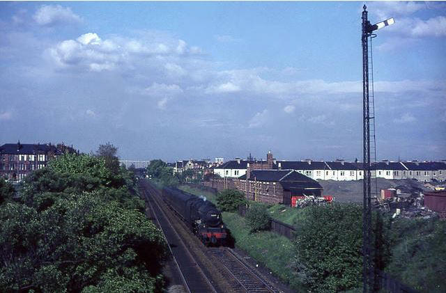
“Black Five” 45489 between Strathbungo and Crossmyloof on 25 May 1965. Note the Council Depot on the right, now Crossmyloof Resource Centre. © John Robin
The architect’s drawings
Aitkenhead’s plans, dated April 1928 , are reproduced here:
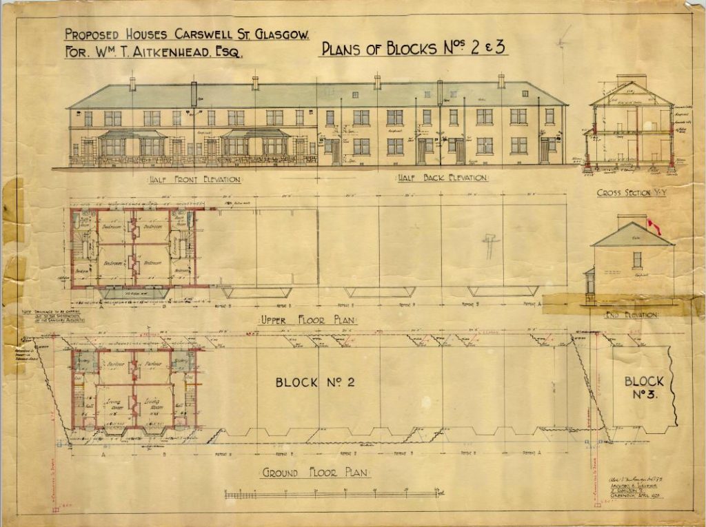
Architectural Drawings for Carswell Gardens – click to enlarge (pdf 2.5MB)

Carswells Gardens Plan – click to enlarge (pdf 2.5MB)
The architect was Alex McGregor, of 2 Hamilton Street, Greenock, at that time the address of the practice of Stewart, Alexander & Tough . Aitkenhead was himself based in Greenock.
The end is nigh
It’s hard to believe that less than 40 years later, the council hatched plans to demolish all these houses for a motorway. But that’s another story.
Meanwhile in 2020 the Council is closing Crossmyloof Resource Centre, which is likely to be replaced by housing.
September 6, 2017 at 4:17 pm
I’m intrigued to hear the story of the proposed demolition!
September 6, 2017 at 8:07 pm
If you haven’t seen it already, it’s here:
https://bygone.bungoblog.com/wp/motorway/
Andrew
And I have now added the link at the bottom of the post.
November 23, 2017 at 6:33 pm
Interesting topic here re-Carswell Gardens and there is another maybe just outside of the Bungo boundary in Victoria Road. The tenement block of flats opposite the old Samaritans Hospital (Queen Mother maternity)/Picture house next to the old Post Office sorting offices, I had been informed that the flat had been build back to front and the architect on realising his error committed suicide. Anybody throw light on this as a true account of history of this particular block of flats?